This item has been sold, but you can enter your email address to be notified if another example becomes available.


|
||

|

|
|

|
Stock# 88906
Description
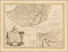
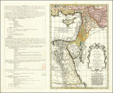
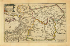
Fine, original antique map of the Holy Land, published in London at the end of the 18th century by Dr. John Trusler and engraved by S. I. Neele.
The map shows the region in fine detail, with mountains and rivers shown, and cities including Jerusalem, Bethlehem, Gaza, and Jafa all shown. Two inset maps in the right show the delimitations of the territory formerly controlled by each of the Twelve Tribes, and below this is a detailed map of Jerusalem.
Condition Description
Minor offsetting.
![(Israel) Tabula Moderna Terre Sancte [Modern Map of the Holy Land]](https://storage.googleapis.com/raremaps/img/small/101884.jpg)