


|
||

|

|
|

|
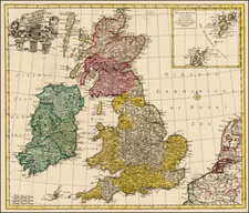
Reiner and Joshua Ottens edition of this attractive double-page engraved map of the British Isles, based on the 1702 De L'Isle map.
The map features a large cartouche in the upper left comprised of numerous sea-related elements and topped by Poseidon.
The Ottens brothers, Reiner and Joshua, operated a successful printing partnership in the mid-eighteenth century (fl. 1726-1765). They began the venture in 1726, publishing maps and other prints as “R & I Ottens.” They specialized in the reprinting of others’ work, especially Guillaume De L’Isle. In 1750, Reiner died; his soon, also Reiner, took his place, but the firm began listing their works as “Joshua & Reiner Ottens.” The firm lasted until Joshua’s death in 1765. Joshua’s widow, Johanna de Lindt, sold their remaining stock of plates in 1784.

![[ Rare English Edition in Full Original Color ] Britannicarum Insularum Typus](https://storage.googleapis.com/raremaps/img/small/101659.jpg)
![[ Pictish Man Holding Severed Head ] Picti icon](https://storage.googleapis.com/raremaps/img/small/99837.jpg)