


|
||

|

|
|

|
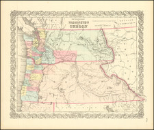
First Separate Atlas Map of the State of Oregon
Interesting large format map of Oregon, the first Atlas map of the state of Oregon to appear in a commercial atlas.
The map notes the two earliest railroad lines operating in Oregon, both West of the Cascades and neither of which traverse the state to it southern border with California.
Several of the counties east of the Cascades now appear, including Baker, Union, Umatilla, Grant, Jackson and Wasco. In the eastern part of the state, Mahta, Orodel, La Grande, Mitchell's Station, El Dorado, Humboldt Basin, Rye Valley, Express Ranch Auburn, Baker City, Forest Cove, Union, and Bakertown are all named east of the Blue Mountains, as is Canyon City, Pendleton, Causo, Marshall and Meadowville to the west, many being holdovers from the gold discoveries of the early 1860s. A number of towns appear along the Columbia. The rail lines of the Oregon - California RR from Portland to Oakland (north of Roseburgh) are shown. Post offices are also located.
One of the most interesting large format commercial maps of Oregon of the early 1870s.
Asher & Adams was a New York publishing firm known for their atlases. Notably, their maps were some of the first to prominently exhibit railroad lines, even if this meant a slight reduction in topographical detail. They specialized especially in state and county maps of the United States.
Asher & Adams was a New York publishing firm known for their atlases. Notably, their maps were some of the first to prominently exhibit railroad lines, even if this meant a slight reduction in topographical detail. They specialized especially in state and county maps of the United States.

![Map of Oregon, Washington and Part of Idaho [First Appearance Of Idaho Territory, including western Montana and Western Wyoming]](https://storage.googleapis.com/raremaps/img/small/94211.jpg)
![[California / Washington / Oregon] Pacific Highway Maps](https://storage.googleapis.com/raremaps/img/small/89058.jpg)
![History of the Expedition under the Command of Captains Lewis and Clark, to the Sources of the Missouri Thence across the Rocky Mountains and Down the River Columbia to the Pacific Ocean, Performed During the Years 1804-5-6 [with map:] Map of Lewis and Clark's Track, Across the Western Portion of North America from the Mississippi to the Pacific Ocean](https://storage.googleapis.com/raremaps/img/small/92506.jpg)