|
||

|

|
|

|
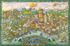
I-5 Prepares to Cut Through the City.
Detailed wall map of Seattle, Washington, published by the local Kroll Map Company in 1958.
The map provides a wealth of detail about the businesses occupying hundreds of lots in downtown Seattle during the middle of the 20th century.
The map shows the proposed route (and ingress and egress areas) for Interstate 5 to run through the middle of the city. Today, the freeway more or less follows the route laid out on this map.
This map provides important information about the businesses and communities that would be displaced by the entrance of a major freeway into the city and the demolition that would have to take place to make that possible.
Seattle has had a complicated and fascinating history with its urban freeways; the Alaskan Way elevated highway was recently demolished, with a replacement thoroughfare buried under the city.
An important document illustrating how the car came to dominate urban life in America during the middle of the 20th century.
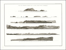
![[Columbia Basin Irrigation Project] Panoramic Perspective of the Spokane Region including the Geological and Scenic Wonderland Embracing the Columbia Basin Irrigation Project and Coulee Dam . . . 1946](https://storage.googleapis.com/raremaps/img/small/77423.jpg)