|
||

|

|
|

|
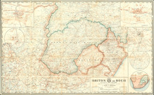
Interesting original antique map showing German designs on resource extraction in colonial southeast Africa at the start of the 20th century.
The map refers to the region known as the Kaokofeld, a coastal desert that is founded in northern Namibia but also southern Angola, most famous as being home to the plant Welwitschia, a "living fossil" and one of the only remaining descendants of the once-extensive Gnetophyta.
The geology shown encompasses a sedimentary sequence as well as some igneous rocks, most notably in the granites of the south and east of the map. An ideal profile through the region is shown at the bottom, with deeply folded sediments intruded by younger igneous intrusions. This region was well-studied during the period of German colonization. It is now protected today by Skeleton Coast National Park.
This map was compiled between 1910 and 1912 and published in 1913 in the Zeitschrift f. praktische Geologie, a German journal of practical geology.

![[ First Modern Map of Southern Africa ] Tabula Moderna Secunde Porcionis Aphricae](https://storage.googleapis.com/raremaps/img/small/66800.jpg)
![[Separately Published Example!] Map of the United States of America. Designed to illustrate the Geological Memoir of Wm. Maclure Esq.](https://storage.googleapis.com/raremaps/img/small/90048.jpg)