|
||

|

|
|

|
Stock# 88856ops
Description
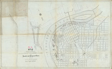
Very rare map of the Seat of War, published by J. Manouvrier & Co. Lith. of New Orleans.
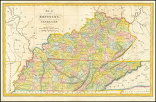
This map shows Kentucky, Tennessee, North Carolina, Virginia and smaller parts of Illinois, Indiana and Ohio. A small inset at left shows the course of the Missouri River. The map was printed in New Orleans, probably in early 1862, at the time of the siege of Forts Henry and Donelson, on the Tennessee and Cumberland Rivers. The capture of these forts was the first major Union victory of the Civil War.
Confederate maps are among the most sought-after of all American imprints. Due to wartime conditions in the South, production values were generally poor.
Condition Description
Variable marginal toning and wear. Minor mat stain. Overall the image is VG to VG+
![[ Indian Territory / North Texas / Arkansas ] General Topographical Map. Sheet XXIV. Plate CLIX](https://storage.googleapis.com/raremaps/img/small/95113.jpg)