


|
||

|

|
|

|
Stock# 88831
Description
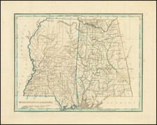
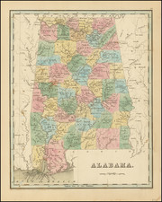
Large detailed folding map of Alabama from the end of the 19th century showing many small towns, roads, rivers, counties, township and range lines, etc.
The map was initially done for the Geological Survey of Alabama but in this edition was repurposed for the 1891 edition of Saffold Berney's handbook of the state.
The map is credited to the State Geologist Eugene Allen Smith.
Condition Description
Folding map with some toning. Otherwise VG+. Overall Good to VG.

![[ French Louisiana ] Carte De la Louisiane par Le Sr. D'Anville Dressee en Mai 1732. Publiee en 1752](https://storage.googleapis.com/raremaps/img/small/88804.jpg)
