


|
||

|

|
|

|
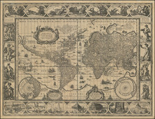
The Final State of Blaeu's Iconic World Map
Striking example of Blaeu's classic world map on Mercator's projection, first issued in 1606.
One of the finest and most famous world maps to appear in an atlas during the Golden Age of Dutch cartography. The map became the Blaeu firm's standard world map in their atlases until 1662, when Joan Blaeu added a double-hemisphere map of the world and later a double-hemisphere polar projection, which was apparently not issued during his lifetime, but was later issued by Valck.
The map's rectangular shape and regular grid of latitude and longitude lines reflect Blaeu's use of Gerard Mercator's projection which Mercator first introduced in 1569. Blaeu's map is essentially a reduced-size version of his wall map of 1605, with basically identical geographical information. As is characteristic of the Mercator projection, the sizes and shapes of land masses in the polar regions are greatly exaggerated. The map is now famous for its elaborate ornamentation, embellished with ships, sea monsters, compass roses, and ornate border panels. Across the top are allegorical representations of the sun and moon and the five known planets - Mercury, Venus, Mars, Jupiter, and Saturn. The four basic elements, fire, air, water, and land, are illustrated on the left panel, while the four seasons are depicted on the right panel. The seven wonders of the ancient world are displayed in the bottom panels.
The map incorporates some of the classic early 17th Century cartographic misconceptions, including the elongated northwest coast of America, massive southern hemisphere with narrow strait between it and South America, incomplete New Guinea attached to large southern continent, etc.
States of the Map:
The present example is state 5 of the map. The states can be determined as follows:
- State 1. The image does not include the signature "Ja. vanden Ende sculpsit." to the lower left of the South Pole projection. Shirley says "possibly a proof".
- State 2. With signature of Josua van den Ende: "Ja. vanden Ende sculpsit"
- State 3. As state 2, but Terra del Fuego is now an island and Fretum le Maire has been added. Probably issued in 1617, as a companion map of Europe bears this date.
- State 4: "Gul. Jansonius 1606" removed and replaced with "Guil. Blaeuw". "Gulielmus Janssonius" replaced with "Gulielmo Blaeuw"
- State 5: Confusingly, this final state, unrecorded by Shirley, adds back the connection between Terra del Fuego and the Southern Continent and some of the coastline erased in the third state.
Willem Janszoon Blaeu (1571-1638) was a prominent Dutch geographer and publisher. Born the son of a herring merchant, Blaeu chose not fish but mathematics and astronomy for his focus. He studied with the famous Danish astronomer Tycho Brahe, with whom he honed his instrument and globe making skills. Blaeu set up shop in Amsterdam, where he sold instruments and globes, published maps, and edited the works of intellectuals like Descartes and Hugo Grotius. In 1635, he released his atlas, Theatrum Orbis Terrarum, sive, Atlas novus.
Willem died in 1638. He had two sons, Cornelis (1610-1648) and Joan (1596-1673). Joan trained as a lawyer, but joined his father’s business rather than practice. After his father’s death, the brothers took over their father’s shop and Joan took on his work as hydrographer to the Dutch East India Company. Later in life, Joan would modify and greatly expand his father’s Atlas novus, eventually releasing his masterpiece, the Atlas maior, between 1662 and 1672.
![[Signed Political Satire Artwork] Vietnam ... Vietnam ... Vietnam ...](https://storage.googleapis.com/raremaps/img/small/68726.jpg)
![[Rare Complete Example with Game Pieces] Grand Circuit Des Capitales. Collection Concours Du Chocolat Menier](https://storage.googleapis.com/raremaps/img/small/70922rd.jpg)
![[Early Photographic Facsimile of the 1527 Weimar Spanish World Map]](https://storage.googleapis.com/raremaps/img/small/67281.jpg)