|
||

|

|
|

|
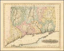
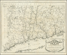
Colonial Connecticut & Rhode Island
Detailed regional map of Connecticut, Rhode Island, and part of Long Island, pubished in London in 1776.
Hartland, east of Colebrook, is labeled "Hartford" (as is the proper Hartford). Torrington is "Corrington" and Old Saybrook is "Seabrook". The Southwick Jog appears to include Suffield, where Stony Brook branches out from the Connecticut River, and Enfield as part of Massachusetts. The copper mines north of Simsbury, which had to be smelted by law in England, became the site of the state's first official prison, also housing prisoners of war during the Revolution. New Cambridge, an area of southwestern Farmington whose residents petitioned the Connecticut Colony to set up their own ecclesiastical society (travel to town was difficult in wintertime), was incorporated as Bristol in 1785.
The map shows towns, roads, rivers, islands, bays and other details.
A highly detailed look at Connecticut, Rhode Island and the northern part of Long Island, at the outset of the American Revolution.
The Gentleman’s Magazine was a British publication that helped to normalize the use of maps in support of articles and features. It was founded in 1731 by the prominent London publisher Edward Cave, a pioneer in periodical journalism. The magazine continued in print for nearly two centuries, shuttering production in 1922.
This was the publication which first used the word “magazine”, from the French for storehouse. Cave wanted to create a storehouse of knowledge and he employed some of London’s best writers to fill his pages: Samuel Johnson gained his first regular employment by writing for the Gentleman’s Magazine. Other famous contributors included Jonathan Swift.
The publication covered a broad range of topics, from literature to politics, and, from 1739, frequently used maps as illustrations. The first map they printed was a woodcut of Crimea; the second was a fold-out map of Ukraine by Emanuel Bowen. Maps were used to show battle lines, to chronicle voyages, and to educate about areas with which Britain traded. Certain geographers, like Thomas Jefferys, contributed several maps to the publication.
![Carte Qui Contient La Maniere Dont Se Fait La Chasse Des Bouefs Sauvages . . . [Buffalo, Niagara Falls, Calumet Village, Huron & Illinois Indians]](https://storage.googleapis.com/raremaps/img/small/93146.jpg)
![[ Pictish Man Holding Severed Head ] Picti icon](https://storage.googleapis.com/raremaps/img/small/99837.jpg)