


|
||

|

|
|

|
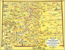
Published by the First Governor of Colorado in a Work on Manifest Destiny.
Great original antique map of the Park System of the Colorado Rocky Mountains, outlining the four basins which can be identified in this portion of the mountains. The naming and advertisement of the "Parks" and their depiction as such was designed to make the regions seem more inhabitable. This work was lithographed by J. B. Lippincott and published in Gilpin's Mission of the North American People, a treatise on the concept of manifest destiny.
This map was first published in 1862 under the title Map of the Colorado Territory, Embracing the Central Gold Region, without emphasizing the system of parks, which would be first included in the 1865 edition. Streeter describes the 1862 edition as the first separate map of Colorado, while Wheat terms it "the first 'indigenous' map of importance...a truly imposing map, a credit to all who had a hand in it..." This third edition was included in Gilpin's Mission in its updated format as presented.
The myth of the "parks" of Colorado were, for the most part, insufficient to persuade mass migration to the high Rocky Mountains, an area, in reality, less hospitable than how it was described by Gilpin. However, the toponyms continue to live on.
William Gilpin was the first territorial governor of Colorado, an appointment he held from 1861 to his downfall in 1862 for issuing $375,000 drafted illegitimately on the US Treasury. He gained some popularity when this fund was used to rally Colorado troops, which defended the territory from a Confederate incursion, but his disorganization and poor financial troubles led to his removal. He became a land speculator in the West and a continued proponent of Manifest Destiny, which led to his publication of the present map.
See Rumsey 3509
![[ Ski Poster ] Breckenridge Colorado](https://storage.googleapis.com/raremaps/img/small/102160.jpg)
![[Austins Colony] Mexico & Guatemala](https://storage.googleapis.com/raremaps/img/small/94054.jpg)
![Mexique par Th. Duvotenay…1842 [Republic of Texas]](https://storage.googleapis.com/raremaps/img/small/93713.jpg)
