


|
||

|

|
|

|
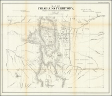
The First Map of Colorado Territory
The first official map of Colorado Territory, based upon state surveys conducted and reported to the General Land Office in Denver City on November 1, 1861.
The map shows the early territorial surveys, an early regional depiction of the Rockies with some place names, as well as Rivers, the Cheyenne and Arapahoe Reservations, mountains, Bent's Fort, Colorado City, Denver, Henderson's Ranch, Ft. St. Vrain, Golden City, Central City, Bradford, Hamilton, Jefferson, Ft. Garland, Pagosa, and handful of other place names.
The Territory of Colorado was established on February 28, 1861. The boundaries of the territory were identical with those of the current State of Colorado. The territory was organized in the wake of the Pike's Peak Gold Rush of 1858-1861. The organization of the territory helped solidify Union control over a mineral-rich area of the Rocky Mountains. Statehood was regarded as fairly imminent, but territorial ambitions for statehood were thwarted at the end of 1865 by a veto by President Andrew Johnson. Statehood for the territory was a recurring issue during the Ulysses Grant administration, with Grant advocating statehood against a less willing Congress during Reconstruction. The Colorado Territory ceased to exist when the State of Colorado was admitted to the Union in 1876.
The General Land Office (GLO) refers to the independent agency in the United States that was in charge of public domain lands. Created in 1812, it assumed the responsibilities for public domain lands from the United States Department of the Treasury. The Treasury had overseen the survey of the Northwest Territory, but as more area was added to the United States, a new agency was necessary to survey the new lands.
Eventually, the GLO would be responsible for the surveying, platting, and sale of the majority of the land west of the Mississippi, with the exception of Texas. When the Secretary of the Interior was created in 1849, the GLO was placed under its authority. Until the creation of the Forest Service in 1905, the GLO also managed forest lands that had been removed from public domain. In additional to managing the fees and sales of land, the GLO produced maps and plans of the areas and plots they surveyed. In 1946, the GLO merged with the United States Grazing Service to become the Bureau of Land Management.
![[ Colorado ]](https://storage.googleapis.com/raremaps/img/small/99487.jpg)
![(Colorado Photographs) [Collection of 22 Rocky Mountain Scenery cabinet cards, including views of Denver, Georgetown, railroads, mining relating scenes and more]](https://storage.googleapis.com/raremaps/img/small/93382.jpg)