|
||

|

|
|

|
The Most Definitive Depiction of "Spanish Hawai'i" Before Cook -- with the Second Appearance of San Francisco on a Printed Map
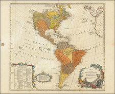
Rare, separately-issued map of America, published by Spain's greatest eighteenth-century mapmaker, Tomas Lopez, in Madrid in 1772.
Lopez's map is of tremendous historical interest for several reasons. As noted by Warren Heckrotte and others, the map is the second printed map to locate San Francisco and is perhaps the only contemporary map to provide a definitive location of "Spanish Hawai'i."
Coming at a time when the Spanish Enlightenment was beginning to allow for the broader dissemination of printed maps detailing the Spanish discoveries in the New World, the map is reflective of the work of Spain's pre-eminent mapmaker, Tomas Lopez. The map provides an up-to-date charting of America, as known to the Spanish. In the tradition of Lopez's training in Paris by J.B.B. D'Anville and others, the map is presented in a scientifically accurate and precise fashion. None of the information contained in the map is based upon myth or conjecture.
To the contrary, in the areas where the information set forth is based upon less than solid reports, symbols of uncertainty are given, such as the dashed line for the western flowing river extending across the northern part of North America. In five places, where reports deemed credible existed, but had not been established with certainty, Lopez reports "lands discovered" by explorers, including
- "Tierra descubierta por Mendana" ("Spanish Hawai'i")
- "Tierras é Islas descubiertas por Quiros" (south of the Marquesas)
- "Tierra que vio Drake" (west of the Straits of Magellan)
- "Tierra que vio Davis" (northwest of Juan Fernandez)
- "Descubrimientos hechos de unos treinta años á esta parte" (discoveries over the past 30 years--referencing the Russian discoveries near the modern Aleutian Islands)
The aforementioned discoveries consist of three of the most famous early, but still unconfirmed, discoveries in the South Pacific by Francis Drake, Pedro Fernández de Quirós and Edward Davis, along with the well known and reported Russian discoveries in the North Pacific.
By contrast, none of the various French theories for the Northwest Passage or the Northwest Coast of America are incorporated into Lopez's chart, despite the tremendous influence of the French mapmakers on Lopez's early training. Robust debates among mapmakers such as Joseph Nicholas De L'Isle, Philippe Buache and the Robert de Vaugondy brothers were still active as late as 1775 in the French Academy of Sciences.
As discussed below, Lopez's location of the lands discovered by Mendaña are worthy of closer study in the context of the claims that the Spanish first reached Hawai'i in the sixteenth-century, as they pre-date any of the other traditionally reported eighteenth-century Spanish sources and, of perhaps greater note, point to "Mendana" as the discoverer of the island(s) in question, rather than the traditional sources (Villalobos (1542) or Gaetano (1555)).
Second map to name San Francisco
Lopez's map of America is perhaps best known as the second printed map to locate San Francisco, following the map of the California Coast by Miguel Costanso (Carta Reducida Del Oceano Asiatico, Ó Mar Del Sur, Que Comprehende La Costa Oriental Y Occidental De La Peninsula De La California), which was also engraved by Lopez in 1771.
As evidence of the rarity of these two maps, despite their publication in 1771 and 1772, the rest of the cartographic world remained ignorant of the existence of San Francisco Bay until 1790, when a copy of Costanso's map was acquired by Alexander Dalrymple in England, who thereafter published an English copy.
The Spanish "discovery" of Hawai'i before Cook
While modern scholars have noted the import of this map for its naming of San Francisco, a feature of this map long overlooked by scholars, in part because of the rarity of this map, is the small section of land along the Tropic of Cancer identified as "Tierra descubierta por Mendana". This note is quite possibly the only known map to accurately memorialize the location of what many believe to be the Spanish discovery of Hawaii in the sixteenth century, more than two hundred years prior to the arrival of Captain James Cook.
While the details supporting Spain's discovery of Hawaii are far from clear, numerous respected journals have seriously reported the Spanish discovery of Hawai'i for well over one hundred years. The modern theories can be traced to La Perouse, who put forth the theory that Juan Gaetano discovered the Hawaiian Islands in 1555, and the report of a map captured by Lord Anson in 1743, which located an island group that corresponded with the location of Hawai'i, as well as Spanish correspondence in the middle of the nineteenth century which articules the claim that Spain had discovered Hawai'i in the mid-sixteenth century.
For example, in the Bulletin of the American Geographical Society, Titus Munson Coan wrote:
The Hawaiian Islands were discovered in the year 1542 by the Spanish Navigator Juan Gaetano. Traces of this early visit may be found in a Spanish [manuscript] map of the sixteenth century which indicates the place of the islands, though somewhat incorrectly as to their longitude . . . (The Hawaiian Islands . . . Vol. XXI, No. 1889, p. 149)
The Spanish discovery of Hawai'i was reported as a "matter of fact" in many other journals published over the next several decades. In the magazine Science (November 7, 1903), John F. Hayford published an article entitled "The Longitude of Honolulu, Various Determinations, 1555-1903," where he commemorated the first Trans-Pacific cable signal to reach Hawai'i with this survey, drawn largely from the work of Hawai'i's Surveyor General, W.D. Alexander. Hayford reports the acquisition by Anson in 1743 of a Spanish Chart wherein:
a group of islands was laid down in the same latitude as the Hawaiian Islands, but 17º too far east. . . .
(and that) an official letter from the Spanish Hydrographical Department to the Hawaiian Government dated Madrid, February 21, 1865, states that an ancient manuscript chart exists in the archives of that office, in which this group is laid down as in the chart of the Spanish galleon, with the name "Islas de Mesa," and a note declaring that they were discovered and named by Juan Gaetano in 1555.
Prior to Cook, there is certainly some evidence to support the discovery of Hawai'i by Spanish explorers in the mid-sixteenth century. The most compelling evidence supports the theory that Juan Gaetano, a Spanish navigator, visited Hawai'i in either 1542 (with Villalobos) or 1555. It is beyond question that Spanish ships were passing within a few hundred miles of Hawai'i during this period, as they regularly sailed between Latin America and the Far East.
Interest in this topic reached its height in the early 1900s. In 1900, Professor William Alexander wrote, "There is little doubt that these islands were discovered by the Spanish navigator, Juan Gaetano, in the year 1555." As noted above, Alexander was citing a document issued in February 1865 from the Colonial Office at Madrid, Spain and addressed to the Governor of the Philippines, which provides in part:
By all the documents that have been examined, it is demonstrated that the discovery [of Hawaii] dates from the year 1555 and that the discoverer was Juan Gaetano or Gaytan. The principal proof is an old manuscript chart, registered in these archives as anonymous, and in which the Sandwich Islands are laid down under that name, but which also contains a note declaring that he called them Islas de Mesa (Table Islands). There are besides other islands situated in the same latitude, but 10 degrees farther east and respectively named La Mesa, La Desgraciade, Olloa or Los Monges. The chart appears to be a copy of that called the chart of the Spanish Galleon, existing long before the time of Cook, and which is referred to by all the national and foreign authors that have been consulted. Foreign authors say that It (the discovery) took place in 1542, in the expedition commanded by General Rui Lopez de Villalobos, while the Spanish chronicles denote 1555.
Two island groups, called Los Monges and Los Bolcanos, appear on a great many maps of the sixteenth, seventeenth and eighteenth centuries, and may represent the Hawaiian archipelago, according to Hawaiian Roman Catholic historian, Father Reginald Yzendoorn. Writing in the 1920s, he notes:
The Los Bolcanos group, consisting of five islands, one of which is called Farfana (probably a misreading for La Tartana), appears for the first time in 1569 on Mercator's map: Nova et aucta orbis descriptio at between 22 and 26 degrees north latitude and about 176 degrees west longitude.
Los Monges are mapped for the first time by Abraham Ortelius on the map of America, made in 1587, and reproduced in the 1612 edition of his monumental atlas: Theatrum Orbis Terrarum. There they are at between 20 and 22 degrees north latitude and 159 and 162 degrees west longitude. Various cartographers during the two following centuries have maintained the Los Monges group on their maps, until Cook rediscovered and renamed them; whilst Los Bolcanos are mapped for the last time by J. A. Maginus in 1617.
Yzendoorn concludes, "A complete study of all these maps leaves no doubt as to the identity of these groups with the Hawaiian Islands."
There are also numerous articles from the same time, and after, refuting the claims that Hawai'i was discovered by the Spanish. These articles argue persuasively that the sources above are simply not sufficiently reliable to establish definitively the Spanish discovery of Hawai'i.
Did "Mendana" discover Hawai'i?
It must be assumed that in referencing "Mendana," Lopez was referring to Álvaro de Mendaña y Neira (1542 - 1595), who was best known for the two voyages of discovery he led into the Pacific in 1567 and 1595 in search of Terra Australis. Mendaña's 1567 manuscript map is one of the most important early manuscript sources for Spanish discoveries in the Pacific.
In his first voyage, Mendaña sailed from Callao, Peru, on November 20, 1567 and reached the Solomon Islands in the South Pacific in February, 1568, before returning to Mexico (by way of the Channel Islands, in California) via the Marshall Islands and Wake Island in 1568-1569. The course from Wake Island to the Channel Islands of California would certainly have taken Mendaña to within a relatively short distance of Hawai'i.
While it is plausible that Mendaña could have visited or sighted Hawai'i on this 1567-1569 voyage, it is also possible that Lopez was merely reporting earlier information derived from Mendaña, although his choice of words ("Tierra descubierta por Mendana") strongly suggests that Lopez believed Mendaña was the discoverer of the lands depicted with this caption.
Lopez's map is perhaps the only map that places the island(s) discovered by the Spanish in almost exactly the correct location of Hawai'i and also distinguishes these discoveries from the so-called Islas de Mesa, which are roughly 15-20 degrees further to the east on this map. Moreover, the manner in which the land is depicted, a partial west coast only (somewhat reminiscent of the west coast of the Big Island), rather than the depiction of a complete island, strongly suggests that Lopez was reporting information which he had derived from a previously unreported Spanish manuscript source.
The disclosure by Lopez of previously secret (or perhaps simply overlooked) information in 1772, at a time when Spain was struggling to retain its claim to mare clausum in the face of the British (Anson, Byron, Wallis, Carteret, and Cook) and French (Louis-Antoine de Bouganville) arrival in the Pacific, would certainly have been of great import. It would have been imperative for the Spanish to put forward their best claims to retention of the Pacific Ocean as a Spanish Dominion, as well as their discovery of islands therein, in the face of competition from other seafaring powers. In fact, the Spanish Fleet in the Pacific was then actively attempting to colonize the Tahitian Islands as a means of solidifying the Spanish hold on their "closed sea."
While there is nothing conclusive about the lands attributed to Mendaña on Lopez's map, it is beyond question that Lopez would have relied upon some existing chart or account for the inclusion of this information and that the timing of the disclosure, coming six years prior to Cook's arrival in Hawai'i in 1778, is compelling circumstantial evidence of an earlier source.
In 1783, Lopez would issue a new map of America with a very similar title, but on a slightly different projection, which locates the Hawaiian Islands just to the south of the location of the prior Mendaña coastline, with the island of San Francisco moved further west and north. Los Monges, La Mesa and Doña Maria Lajara are left virtually unchanged.
In summary, while we draw no conclusions on the underlying question of Spanish primacy in the discovery of Hawai'i, the Lopez map presents a compelling new chapter in the discussion, adding to the pro-Spanish discovery argument a map engraved six years prior to Cook's visit to Hawai'i by Spain's pre-eminent mapmaker and introducing for the first time the name Álvaro de Mendaña as a possible discoverer of Hawai'i.
Rarity
The 1772 Lopez map of America is of the utmost rarity. We have located examples in the National Libraries of Spain and France, along with a copy which appeared in a five-map composite atlas in the Warren Heckrotte collection (ex Warren Howell), sold at auction in October 2015.
We note one example at auction in the past thirty years (this example, sold in 2009 and repurchased by this firm in May 2021), with one example located in an American institution (American Antiquarian Society). We also handled an uncolored example of the map in February 2016.
Later 1783 and 1794 editions were issued, utilizing a different projection, and they appear to be of a similar rarity.
Tomás López de Vargas Machuca (1730-1802) was one of Spain’s most prominent cartographers in the eighteenth century. He was born in Toledo but studied at the Colegio Imperial in Madrid, where he focused on mathematics, grammar, and rhetoric. Along with a small group of colleagues, in 1752 the Spanish government sent López for training in Paris with the renowned geographer Jean Baptiste Bourguignon d’Anville. When he returned to Spain he was named Geógrafo de los dominios de Su Magestad and put in charge of the geographic collections of Charles III. He published many maps, including his fascinating maps of the Americas, and a variety of geography manuals. Some of his most famous maps are of the Iberian Peninsula, part of his large project to create a majestic atlas of Spain. Unfinished in his lifetime, López's children published the Atlas Geográfico de España (Geographical Atlas of Spain) in 1804. It was republished in 1810 and 1830.
![Lands of the Hemet Land Co. [Hemet Southern California. Its homes and scenes]](https://storage.googleapis.com/raremaps/img/small/89106.jpg)
![(Malaspina Expedition): [Group of six manuscript documents, signed, related to a future assignment for the officers of the Malaspina expedition, including a voyage to chart the coast of Guatemala and to explore Nicaragua, proposed by the viceroy of New Spain]](https://storage.googleapis.com/raremaps/img/small/101838.jpg)