


|
||

|

|
|

|
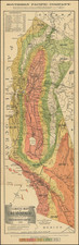
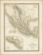
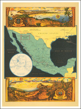
One of the best large format maps of Mexico, Texas and Upper California to appear in a commercial atlas in the early1850s.
Texas is now a part of the US, with dozens of place names shown, a well as the road from Natchtoches to the Loredo area. Substantial detail throughout the Rocky Mountains, incorporating Humboldt, Pike and Long. The west reflects nicely updated post-Fremont cartography, with several early roads noted and excellent up to date detail, especially in the Gold Regions of California. The route to the Gold Fields via Salt Lake and route from St. Louis to Santa Fe are shown.
Rarity
This late edition of Lapie's map of the Southwest rarely appears on the market. It reflects a tremendous amount of revision from the early editions and is a worthwhile addition to a Southwestern & California map collection.
This is the second example we have offered for sale in 25 years.
![(Pacific Coast Exploration) Relacion del viage hecho por las goletas Sutil y Mexicana en el año de 1792 para reconocer el Estrecho de Fuca: con una introduccion en que se da noticia de las expediciones executadas anteriormente por los españoles en busca del paso del noroeste de la América. [Account of the voyage undertaken by the schooners Sutil and Mexicana in the year 1792 to explore the Strait of Juan de Fuca: with an introduction that provides information about the expeditions previously carried out by the Spaniards in search of the Northwest Passage of America.]](https://storage.googleapis.com/raremaps/img/small/94653.jpg)