|
||

|

|
|

|
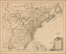
Rare Gadsden Purchase Edition of Colton's Finest Large Format Map of the United States. Unusual Appearance of C.C. Hall in Portland, Maine, as co-publisher.
Important 1855 state of JH Colton's wall map of the United States This is the first state to introduce the results of the Gadsden Purchase and the first to include significant revisions in Arizona, Nevada, and southeastern California, with significant improvements to the Colorado River, San Juan River, Mojave River, Grand Canyon region, and much of the region west of the Front Range of Colorado Rocky Mountain region.
Colton’s wall map of the United States is not just a visual masterpiece in cartography; it encapsulates the massive strides that the nation had achieved in only a few generations. Part of a series of wall maps first issued in 1848 and periodically updated for the next decade, this monumental four-sheet wall map of the United States was produced at a time when the Transmississippi West was still taking shape and the violent throngs of Civil War had not yet engulfed the nation. The map was produced in multiple states between 1853 and 1856 and shows the progression of the colonization of the West, from the acquisition of Texas and Upper California, through Bleeding Kansas and the Gadsden Purchase and up to the period immediately prior to the Civil War.
It also shows the recently-formed Kansas and Nebraska Territories, formed on May 30th, 1854, when President Franklin Pierce signed the Kansas-Nebraska Act into law.
Geography of the Map
Being among the most important American mapmakers of his time, Colton possessed abundant information and older maps and plates to draw upon when compiling the cartography in the densely inhabited eastern part of America. However, it is the West that belies the true importance of the map. The inclusion of Kansas and the Gadsden Purchase is just one of many interesting and age-specific features that characterize the map and make it one of the most poignant visualizations of the United States in the middle of the 19th century.
Although still part of a larger ‘Indian Territory’ that stretched into Kansas as well, the shape of what would one day become Oklahoma is clearly identifiable on Colton’s map. Its characteristic panhandle has nevertheless been distinctly colored and separately classified. During the early 1850s, this strip of land underwent a number of statutory and affiliative changes. Thus, in the first edition of this map, Colton included the panhandle as part of Texas, but from the second edition onward these public lands have been re-classified as ‘unorganized territories’. The subsumption of these lands first to the ‘Indian Territories’ of Oklahoma in 1890 and later to the new state of Oklahoma (established in 1907), was still many years away when this map was published.
On the map, the Utah Territory remains one enormous entity with no trace of Nevada in sight. Nevada, of course, would be rushed into statehood in 1864 (30 years before Utah!), in order to ensure that it would support Lincoln in the General Election that same year. Nebraska is another clear example of the historicity of this map. It extends from the new border with Kansas in the south to the Rocky Mountains in the west and the Canadian border in the north, effectively encompassing the modern states of North and South Dakota, Wyoming, Montana, and of course Nebraska itself. As if to underline the persisting frontier character of this territory. This is the first state of the map in which Colton ceases to use the somewhat antiquated label ‘Northwest Territory’ to designate this region.
Washington and Oregon Territories are clearly delineated and extend all the way to the Rockies, encompassing what in 1890 would become the state of Idaho. The newly acquired Territory of New Mexico extends across an equally massive stretch from Texas in the east to California in the west. Looking at the western part of America, one is struck by the massive ridge line of the Rocky Mountains, which cuts through the landscape. The mountains of this region themselves have been rendered in exceptional detail for the time, and clearly show that Colton had had the opportunity to draw on the reports of John Charles Frémont, also known as ‘The Pathfinder’. Frémont was an American officer and explorer, and the first Republican presidential candidate. Between 1842 and 1846 he led several expeditions to explore the Rockies, producing extraordinary maps as a result. Aside from a decisive cartographic achievement, Frémont’s work epitomized the spirit of an age, in which intrepid explorers mapped wild lands under the aegis of the expanding American nation. The level of detail is echoed in other western ranges, such as in the ranges of the Sierra Nevada, also explored by Frémont.
Decorative Elements
A note should be made on the decorative elements of this map. In addition to a visually powerful color scheme that subdivides the entire country into states and territories, the map is covered with an array of small symbolic or evocative vignettes. These include vivid renditions of American wildlife: deer in Kansas; a bear in the Northwest Territory; beavers north of the Great Lakes; moose, wolves, and arctic foxes at play in Canada; and exotic birds in the Caribbean. Other well-known motifs include traditional images of frontier life: trapping, hunting, canoeing; scenes of Native Americans engaged in ritual dance; and a wagon trail scene in central Oregon. The maritime space is also full of enticing and extremely well-executed images. Many of these are different kinds of ships, but they also include identifiable phenomena such as volcanos and specific coastal views, as well as characteristic Central American crops such as sugar cane and palm trees.
At the bottom of the map we find two insets. In the lower-left corner, the publisher has included a rather detailed little map of the Central American isthmus. The region has of course been featured because of its importance on the route to California, in which passengers sailed down from the Atlantic, made the overland trek across the isthmus, and then continued on again by sea up the west coast.
In the lower right side of the map, squeezed in between the general map’s table of Statistics of the United States and Table of Distances, we find a similar inset of the West Indies archipelago. This too is quite detailed and has its own title, scale bare, graticules, and landscape vignette. While seemingly reasonable additions to this type of map, both insets are in fact reflections of the rising geo-political interests entertained by America at the time. Such outward aspirations would of course soon be thwarted by internal strife (i.e. the upcoming Civil War), but by the end of the century, the United States would make her heavy presence felt in both of the inserted regions.
The History of the Gadsden Purchase and its Portrayal on Colton's Wall Map
The Gadsden Purchase sprang from border disputes following the Treaty of Guadalupe Hidalgo, the treaty that brought a formal end to the Mexican-American War on February 2nd, 1848. While the treaty was quite specific in terms of where the border was to be drawn, the job of securing that border from Indian attacks fell to the Americans. The Mexican government soon claimed that the U.S. was failing in this regard and demanded large sums in compensation for their losses. In 1853, the newly appointed U.S. president, Franklin Pierce, appointed James Gadsden as the ambassador to Mexico. The appointment came with a specific brief: purchase as much land in northern Mexico as possible. Initially, the idea was to acquire large swathes including all of Baja California, Chihuahua, Sonora and beyond. The Mexican government was not interested in selling further territories to the United States, but at the same time wanted to avoid war at all costs. Moreover, Mexican president Santa Anna desperately needed funds for his government and so a deal was brokered.
While the Purchase was agreed in December of 1853 and finalized in 1854, Colton, in his 1854 edition, refrained from incorporating this sensitive political issue and depicted the border with Mexico as it had been since the Mexican-American War. In the present 1855 edition, however, we see the border has, in fact, been updated. The old border along the Gila River and the new border are both demarcated, separated by a thin orange strip of land. The southern of these borders is marked "Border between the United States and Mexico according to tot the Treaty of 1854."
States
The known states of this map are described below.
- First state: 1853. Pre-Gadsden and pre-Kansas-Nebraska Act.
- Second state: 1853 date added.
- Third state: Date updated to 1854: Kansas added as a territory. Indian territory reorganized to match Oklahoma. Nebraska Territory reaches the Canadian Border.
- Fourth state: Date updated to 1855. The present. Gadsden Purchase Recognized.
- Fifth state: Date updated to 1856.
Rarity
We have only been able to trace three examples of this important 1855 state through OCLC and other sources. Known institutional holdings are the Huntington Library, Denver Public Library, and National Library of Scotland.
Wheat Transmississippi 776, p 161.
Wheat Gold Region 255
Martin & Martin, Maps of Texas and the Southwest, #43.
G. W. & C. B. Colton was a prominent family firm of mapmakers who were leaders in the American map trade in the nineteenth century. Its founder, Joseph Hutchins Colton (1800-1893), was a Massachusetts native. Colton did not start in the map trade; rather, he worked in a general store from 1816 to 1829 and then as a night clerk at the United States Post Office in Hartford, Connecticut. By 1830, he was in New York City, where he set up his publishing business a year later.
The first printed item with his imprint is dated 1833, a reprint of S. Stiles & Company’s edition of David Burr’s map of the state of New York. He also printed John Disturnell’s map of New York City in 1833. Colton’s next cartographic venture was in 1835, when he acquired the rights to John Farmer’s seminal maps of Michigan and Wisconsin. Another early and important Colton work is his Topographical Map of the City and County of New York and the Adjacent Country (1836). In 1839, Colton began issuing the Western Tourist and Emigrant’s Guide, which was originally issued by J. Calvin Smith.
During this first decade, Colton did not have a resident map engraver; he relied upon copyrights purchased from other map makers, most often S. Stiles & Company, and later Stiles, Sherman & Smith. Smith was a charter member of the American Geographical and Statistical Society, as was John Disturnell. This connection would bear fruit for Colton during the early period in his career, helping him to acquire the rights to several important maps. By 1850, the Colton firm was one of the primary publishers of guidebooks and immigrant and railroad maps, known for the high-quality steel plate engravings with decorative borders and hand watercolors.
In 1846, Colton published Colton’s Map of the United States of America, British Possessions . . . his first venture into the wall map business. This work would be issued until 1884 and was the first of several successful wall maps issued by the firm, including collaborative works with D.G. Johnson. From the 1840s to 1855, the firm focused on the production of railroad maps. Later, it published a number of Civil War maps.
In 1855, Colton finally issued his first atlas, Colton’s Atlas of the World, issued in two volumes in 1855 and 1856. In 1857 the work was reduced to a single volume under the title of Colton’s General Atlas, which was published in largely the same format until 1888. It is in this work that George Woolworth (G. W.) Colton’s name appears for the first time.
Born in 1827 and lacking formal training as a mapmaker, G. W. joined his father’s business and would later help it to thrive. His brother Charles B. (C. B.) Colton would also join the firm. Beginning in 1859, the General Atlas gives credit to Johnson & Browning, a credit which disappears after 1860, when Johnson & Browning launched their own atlas venture, Johnson’s New Illustrated (Steel Plate) Family Atlas, which bears Colton’s name as the publisher in the 1860 and 1861 editions.
J.H. Colton also published a number of smaller atlases and school geographies, including his Atlas of America (1854-56), his Illustrated Cabinet Atlas (1859), Colton’s Condensed Cabinet Atlas of Descriptive Geography (1864) and Colton’s Quarto Atlas of the World (1865). From 1850 to the early 1890s, the firm also published several school atlases and pocket maps. The firm continued until the late 1890s, when it merged with a competitor and then ceased to trade under the name Colton.

![A Map of Lewis and Clark's Track Across the Western Portion of North America, from the Mississippi to the Pacific Ocean. By Order of the Executive of the United States in 1804, 5 & 6. . . . [Complete with 3 volumes of Text: Travels to the Source of the Missouri River and Across the American Continent to the Pacific Ocean. Performed by Order of the Government of the United States, in the Years 1804, 1805, and 1806].](https://storage.googleapis.com/raremaps/img/small/81775.jpg)