The item illustrated and described below is sold, but we
have another example in stock. To view the example which
is currently being offered for sale, click the
"View Details" button below.


|
||

|

|
|

|
Stock# 88571
Description
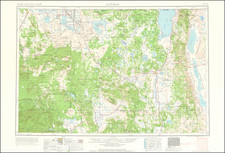
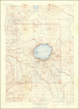
Attractive separate topographical map of Crater Lake National Park, in Oregon.
This is the 1946 edition of the map with information gleaned from previous surveys in 1886, 1908, 1909, and 1933.
The map includes 1945 road classifications including:
- Dependable hard-surface heavy-duty road
- Secondary hard-surface all weather road
- Loose-surface garded
- Unsurfaced, graded
- Dirt road
- U.S. Route
- State Route
Topography is rendered with contour lines.
There is an illustrated essay describing Crater Lake by Francois E. Matthes on the back of the map.
![[California / Washington / Oregon] Pacific Highway Maps](https://storage.googleapis.com/raremaps/img/small/89058.jpg)