


|
||

|

|
|

|
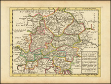
Buache edition of De L'Isle's attractive map of the southernmost part of Swabia, on the Swiss border near the Bodensee (Lake Constance).
The map shows the region in fine detail, with cities, towns, forests, rivers, and other geographical features all shown. The start of the Alps to the southeast of the map is just about visible. The German city of Konstanz is shown.
Guillaume de L'Isle was one of the leading French cartographers of the first part of the 18th century. Following his death, many of his copperplates were inherited and reissued by Phillipe Buache.
Philippe Buache (1700-1773) was one of the most famous French geographers of the eighteenth century. Buache was married to the daughter of the eminent Guillaume Delisle and worked with his father-in-law, carrying on the business after Guillaume died. Buache gained the title geographe du roi in 1729 and was elected to the Academie des Sciences in the same year. Buache was a pioneering theoretical geographer, especially as regards contour lines and watersheds. He is best known for his works such as Considérations géographiques et physiques sur les découvertes nouvelles dans la grande mer (Paris, 1754).

![[Alsace] Alsatia Superior cu Suntgoia & Brisgoia](https://storage.googleapis.com/raremaps/img/small/54970.jpg)
