|
||

|

|
|

|
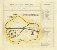
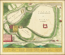
The earliest printing of Pietro Vesconte's Important 14th-Century Map of Jerusalem.
The rare 1611 Johann Bongars edition of the Vesconte chart of Jerusalem, one of the finest Medieval town plans of the city.
Based on a manuscript plan by Vesconte, the map shows the Holy City during biblical times. It labels the homes (domus) of King Solomon, Pilate, and St. Anne, and shows the Church of the Holy Sepulchre (sepulchrum domini). The map shows the Kidron as a vast river encircling Jerusalem. Roads lead into and out of the city, and the city's fortifications are shown.
Bongars and the Printing of Vesconte's Map
Pietro Vesconte was a Genoese cartographer and one of the earliest creators of portolan charts. He operated primarily out of Venice, and greatly influenced Italian and Catalan mapmaking throughout the 14th and 15th centuries. He is widely regarded as having been the first professional mapmaker to habitually sign and date his works. Vesconte's portolan of the Eastern Mediterranean (1311), is the oldest known signed and dated map.
Vesconte created a groundbreaking 'Portulano', or World Map, which contained many geographically progressive elements. He was also the first mapmaker to accurately map the Mediterranean and Black Seas, and (relatively) the Holy Land and his depiction of Great Britain was a marked improvement over his predecessors. At least four of his multi-chart atlases survive, dating from 1313 to 1321.
Johann Bongars created this finely executed version of the Vesconte map as part of the greater intellectual movement that flourished in Europe, and in Germany in particular, roughly from 1450 to 1650, during which scholars, heavily influenced by the enlightened ethic of Humanism, sought to acquire, preserve and learn from the most progressive elements of Classical and Medieval thought. These scholars sought to go "ad fontes", or 'to the original source' of the knowledge, or as close to it as possible.
In 1611, Bongars printed his Gesta Dei Per Francosi, which included a collection of maps by Vesconte as well as Marino Sanudo's text on the Crusades. Sanudo was a Venetian statesman and geographer best known for his lifelong attempts to revive the crusading spirit and movement. He wrote his great work, the Secreta or Liber Secretorum Fidelium Crucis, also called Historia Hierosolymitana, Liber de expeditione Terrae Sanctae, and Opus Terrae Sanctae.
Jacques Bongars, Seigneur de Bauldry et de La Chesnaye, was a French diplomat and classical scholar who compiled a history of the Crusades.
A Huguenot, Bongars studied in Germany, Italy, and Constantinople. From 1586 Henry of Navarre (later King Henry IV of France) sent him on missions to obtain men and money from the German princes and from Queen Elizabeth I of England. As French minister in Germany (1593–1610) he tried to unite Protestant princes in a league with King James I of England at its head.
Bongars published an annotated edition of the Roman historian Justin’s works in 1581 and a French translation of the letters of Aristaenetus in 1597. He was interested, however, not only in ancient writings but also in medieval chronicles. His collection of historical works on Hungary (1600) was followed, in 1611, by the far more important Gesta Dei per Francos (“God’s Work Through the Franks”), a collection of contemporary accounts of the Crusades. An edition of his letters, in Latin, appeared in 1647, a French translation in 1668–70. His diary of his journey to Constantinople was printed in 1874.
Pietro Vesconte was a fourteenth-century mapmaker best known for his pioneering portolan charts. Born in Genoa, he performed the bulk of his work in Venice between 1310 and 1330.
While portolan charts are known to have existed since at least the thirteenth century, Vesconte significantly improved on the form and produced highly-accurate charts of the Mediterranean, the Black Sea, and Northern Europe. His 1311 chart of the eastern Mediterranean is the oldest signed and dated nautical chart. He also made at least four signed atlases. One of these, a 1318 atlas, includes an image of a chartmaker at work which is likely Vesconte. The cartographer also made several maps, including a distinctive mappa mundi included in Marino Sanuto’s Liber secretorum fidelium crucis.
![[Jerusalem] Grundriss der Stadt Jerusalem wie sie Furnemlich zur zeit dess herzn Christi. . .](https://storage.googleapis.com/raremaps/img/small/90630.jpg)