


|
||

|

|
|

|
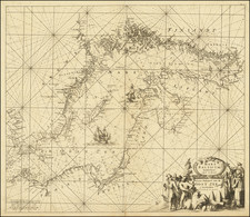
Rare example of Nicholas Sanson's map of the Bohuslän region in Sweden, from his uncommon suite of Scandinavian maps.
This map shows the region in fine detail, naming cities, towns, rivers, mountains, and more. Lake Vänern is shown in part.
Bohuslän takes its name from the nearby Norwegian castle of Bohus, and the region traded hands between Sweden, Denmark, and Norway frequently.
Maps of inland Swedish regions from the 17th century showing inland detail are rare, as this region was not as much of a focus for the cartographers of western Europe who specialized in making maps of their home regions or of areas where trade was occurring.
The son of famous French cartographer Nicolas Sanson, Guillaume (1633-1703) carried on his father's work. Like his sire, he was a court geographer to Louis XIV. He often worked in partnership with another prominent cartographer of the time, Hubert Jaillot.
![[Swedish Cities] Charta ofwer Upstaden Wadstena No. XLVIII [with] Charta ofwer Upstaden Skeninge No. XLIX.](https://storage.googleapis.com/raremaps/img/small/70095.jpg)
![[ Gotland ] Geo=Hydrographisk Chara ofwer Provincen Gothland](https://storage.googleapis.com/raremaps/img/small/101581.jpg)
![[Swedish Cities] Charta ofver Upstaden Carlstad No. XXXVII [with] Charta ofver Upstaden Christinehamn No. LXVII [with] Charta ofver Bergstaden Philipstad No. LXXIX](https://storage.googleapis.com/raremaps/img/small/70207.jpg)
![[Map of Sweden and Norway] Карта Швеціи и Норвегіи](https://storage.googleapis.com/raremaps/img/small/66784.jpg)