|
||

|

|
|

|
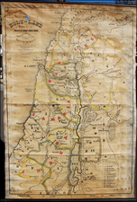
Rare map of the land of Moab, or the region to the east of the Dead Sea. This map shows the region in fine detail and was published by the Palestine Exploration Fund, perhaps the most important mapping organization active in the Holy Land during the 19th century.
The map is extremely detailed. The Dead Sea is shown in full, with detail extending to the east. Roads, topography, and more are shown. The locations of various biblical cities, including Bezer and Jabaz, are guessed at according to the research of the Fund. Moab was a Biblical kingdom that often conflicted with the Israelites and was often mentioned in the Old Testament.
A variant of this map appeared in the Quarterly Statement of the Palestine Exploration Fund in 1871 and 1872. The variant has Stanford's publishing house's information at the bottom of the map, along with a scale bar. It appears that this map was photolithographed from that map for a separate publication of the same era.
![(The Tabernacle) Sacri Tabernaculi Icnographia Bened. . . . [on sheet with:] Sacri Tabernaculi Orthographia . . .](https://storage.googleapis.com/raremaps/img/small/83961.jpg)
![[ Descendants of Noah ] Table historique du second age du monde tiree de la Genese...](https://storage.googleapis.com/raremaps/img/small/82009.jpg)