


|
||

|

|
|

|
Magnificent Two Volume G. G. Rossi World Atlas Bound In-Plano
Rossi's Mercurio Geografico was the first folio atlas of the World published in Italy in the 17th century. It is arguably the first modern Italian atlas of the world published in Italy. Its predecessors were all either editions of Ptolemy's Geography or Lafreri-style composite atlases, made to order. Beginning in the late 1660s, Rossi's atlas would grow over the successive decades, becoming the source for the multi-sheet maps of Giacomo Cantelli da Vignola, one of Italy's most important mapmakers of the late 17th century.
Apart from some maps signed by French cartographers Michael Antoine Baudrand, Guillaume Sanson, Nicholas Sanson, and Augustin Lubin, most of the papers are by Cantelli. Among the engravers are the names of Jean Lhuillier, Francesco Donia, Vincenzo Mariotti, and others. The Cantelli-Rossi atlas had great success and continued to be published, even after the death of Cantelli, until the eighteenth century, with the addition of a second part and numerous new maps
The present atlas, with a total complement of 130 maps, reflects Rossi's continuing effort to expand the work. The atlas begins with Brunacci's highly sought-after double hemisphere celestial map and ends with a set of 12 newly published maps of European regions, available in 1690, but not yet incorporated into a revised catalog of maps. The dated maps mostly range from 1669 to 1697, with two outliers dated 1702 (vol. 1) and 1703 (in vol. 2).
While some of Rossi's maps are drawn from French Royal Geographer Nicolas Sanson, the vast majority of the maps are the original works of Giacomo Cantelli da Vignola, and reflect a unique engraving style.
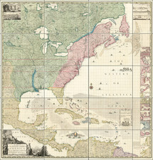
The map of North America (here dated 1687) is in what Burden describes as the second state, unchanged cartographically from the first state dated 1677. While it's largely based on Guillaume Sanson's map of 1669, which in turn was based on his father Nicolas Sanson's wall map of 1666, the Rossi map adds Iceland, the British Isles, and the recurrence of C[abo] Blanco on the northern California coast. California is shown as an island in the Foxe form of 1635.
The atlas includes a number of multi-sheet maps, several of which include magnificent large cartouches. There is considerable variation in the contents of this altas, which includes maps by or after Cantelli da Vignola, the Sansons, and others, as is normally the case. Rossi atlases can vary widely in their total content, with editions ranging from about 50 maps to over well 100 maps by the beginning of the 18th century, by which time the maps of other makers are often found in the atlas.
The last example of a "pure" Cantelli-Rossi atlas to appear at auction with more than 100 maps was in 2006, with examples typically ranging from 40-68 maps.
Giacomo Giovanni Rossi (1627-1691) was an Italian engraver and printer. He worked in Rome, the heir to an important printing business founded by his father, Giuseppe de Rossi (1570-1639). Giuseppe began the press in 1633 and Giovanni and his brother, Giandomenico (1619-1653) took it over upon his death. The brothers expanded the business and by the mid-seventeenth century it was the best-known printing house in Rome.
For his maps, Giovanni worked with Giacomo Cantelli da Vignola. They produced the Atlas Mercurio Geografico. The first edition is undated, but the second was issued in 1692, a year after Giovanni’s death. The maps were by Cantelli. The firm also published maps based on those of Nicolas Sanson.
Later, the business passed to Lorenzo Filippo (1682-?). By 1738, the firm was known as Calcografia Camerale, then, from 1870 to 1945, as the Regia Calcografica. Today, the firm is still in business and is called Calcografia Nazionale. It operates as a free museum and offers one of the best collections of prints and plates in the world.
![Watson's New Commercial County and Railroad Atlas of the United States and Dominion of Canada. Compiled from the Latest Official Sources. [Cover title:] Perry & Spauldings New Commercial County & Railroad Atlas...](https://storage.googleapis.com/raremaps/img/small/90103.jpg)