|
||

|

|
|

|
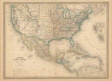
Fine early wall map of the United States, published shortly after the Kansas-Nebraska Act of 1854, published by Charles Morse and Samuel Gaston in New York in 1857. (Though the main title lists the date as 1856, the inset world map is dated 1857, and the publishing partnership post-dates the Johnson and Gaston production of the map.)
Extending from Coast to Coast, the map is of greatest interest for its depiction of the Western States and Territories shortly after the creation of Kansas.
- A massive Minnesota Territory, covering much of the Dakotas
- Nebraska extends to the Rocky Mountains and the Canadian Border
- Oregon & Washington extend to the Rocky Mountains
- New Mexico Territory and Utah Territory extend from California to the Rocky Mountains.
The west is filled with Indian Tribes, early forts, and the major wagon roads. The map makes an excellent attempt to depict the earliest Western Counties.
Early Appearnce of Manti, Utah
Among the more interesting features of the map is the early appearance of Manti City (on the first communities in Utah) near the Wasatch Gap. In 1849, Brigham Young dispatched a company of settlers to the Sanpitch (now Sanpete) Valley. Under the direction of Isaac Morley and George Washington Bradley, the settlers arrived at the present location of Manti in November, 1849. Brigham Young named the new community Manti, after a city mentioned in the Book of Mormon. Manti was incorporated in 1851.
This is one of the first appearances of Manti on a printed map, which also appears on the map of Utah in James Linforth's James Linforth's Route from Liverpool to Great Salt Lake Valley, published in 1855.
The Kansas-Nebraska Act was an 1854 bill that mandated “popular sovereignty”–allowing settlers of a territory to decide whether slavery would be allowed within a new state’s borders. The bill was proposed by Stephen A. Douglas, Abraham Lincoln’s opponent in the influential Lincoln-Douglas debates and overturned the Missouri Compromise’s use of latitude as the boundary between slave and free territory. The conflicts that arose between pro-slavery and anti-slavery settlers in the aftermath of the act’s passage led to the period of violence known as Bleeding Kansas, and the American Civil War (1861-65).
This 1854 bill to organize western territories became part of the political whirlwind of sectionalism and railroad building, splitting two major political parties and helping to create another, as well as worsening North-South relations.
The act passed Congress, but it failed in its purposes. By the time Kansas was admitted to statehood in 1861, southern states had begun to secede from the Union. The Independent Democrats and many northern Whigs abandoned their affiliations for the new antislavery Republican party, leaving southern Whigs without party links and creating an issue over which the already deeply divided Democrats would split even more. The railroad was eventually built but not along the route Douglas wanted and with funds voted by a Republican Congress during a Republican Civil War administration.
Rarity
This is the presumed fourth state of the map from 1857. The map was first published in 1854 and again in 1855, and later by J.G. Wells, New York. Mack R. Barnitz, Cincinnati, Ohio.
All states of the map are rare, especially in nice condition.

![[ Promoting Emigration To The Czech Market ] Ceske Osady V Americe [ A Correct Map of the United States of America Showing Atchison, Topeka and Santa Fe R.R. and Connections ]](https://storage.googleapis.com/raremaps/img/small/101348.jpg)