|
||

|

|
|

|
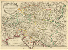
Fine original antique map of central Europe, showing the southern part of the region under Austria's sphere of influence in the middle of the 18th century.
The map shows southern Austria and northern Italy in great detail. The map names, in English, many cities, rivers, lakes, towns, mountain ranges, and more. The map stretches northwest to Salzburg, northeast to the Danube River, and south to the Istrian Peninsula.
The map includes two cartouches, one with a dedication to the Duke of Cornwall. The map follows the cartography and style of Nicholas Sanson, one of the great French mapmakers of the 17th century, who is credited in the upper right.
This map was made by William Berry, one of the few 17th-century English cartographers. His maps are rare due to their separately-issued nature, and they were usually included in custom-made composite atlases.
![[ Vienna ] Viennense Territorium ob res Bellicas Inter Christianos et Turcas Nuperrime Editum](https://storage.googleapis.com/raremaps/img/small/80253.jpg)
![[ Tyrolia] A New Map of the County of Tyrol, And the Republic of Venice; Duchy of Mantua &c &c . . . 1799](https://storage.googleapis.com/raremaps/img/small/101127.jpg)