


|
||

|

|
|

|
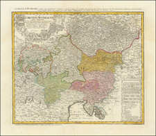
Fine original antique map of central Europe, showing the region under Austria's sphere of influence in the middle of the 18th century.
The map shows the region in fine detail, naming many cities, rivers, lakes, towns, mountain ranges, and more. Cities shown include Prague, Vienna, Budapest, and Trieste. The map includes two regal Germanic cartouches, one with coats of arms in the upper left and one with a table of distance measurements in the lower right.
This map was published by the inheritors of the Homann publishing firm, who issued their works in Nuremberg and Paris. It is for this reason that the title is also given in French as "Le Cercle D'Autriche, consistant dans. . ."
Homann Heirs was a German publishing firm that enjoyed a major place in the European map market throughout the eighteenth century. Founded in 1702 by Johann Baptist Homann, the business passed to his son, Christoph, upon Johann’s death in 1724. Christoph died in 1730, aged only 27, and the firm was inherited by subsequent Homann heirs. This altered the name of the company, which was known as Homann Erben, or Homann heirs. The firm continued in business until 1848.

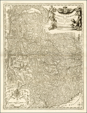
![[ Lago di Garda ]Carte Nouvelle du Territoire de Verone levee pare ordre expres. a l'Usage des Armees en Italie; ou sont Exactement Marques les Grands Chemins, les Routes des Imperiaux &c.](https://storage.googleapis.com/raremaps/img/small/56727.jpg)
![[Tuscany, Rome, Siena, Pisa, Florence, etc] Status Ecclesiasticus Magnus Ducatus Thoscanae](https://storage.googleapis.com/raremaps/img/small/37120.jpg)
![[ Holy Roman Empire ] S. Imperium Romano-Germanicum oder Teutschlenad mit Seinen Angrantzenden Konigreichen und Provincien,...](https://storage.googleapis.com/raremaps/img/small/98433.jpg)
![[ Postal Map of Eastern Europe ] Deutschlands Postkarte begraenzt von Oesterrreich, Preussen, Frankreich, Holland, Italien und der Schweiz. Gezeichnet und Herausgegeben von Ignaz Heymann. K.K. Obserpostamtsoffizier in Trieste. 1800.](https://storage.googleapis.com/raremaps/img/small/77678.jpg)