This item has been sold, but you can enter your email address to be notified if another example becomes available.


|
||

|

|
|

|
Stock# 88354
Description
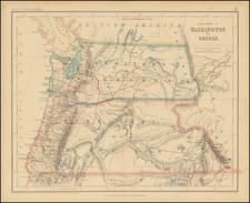
An interesting land-use map of southern Montana, showing the vegetation coverage present in the region and published as part of a professional paper on the forest conditions in the area.
The map stretches in coverage from the Wyoming border near the Custer Gallatin National Forest northwards to Big Timber and the course of the Northern Pacific Railroad. Detail is extensive, with contour lines and many rivers, streams, and more shown.
The map includes ten different types of classifications, mostly focused on the concentration of wood resources. The limits of the Yellowstone Forest Reserve are shown.
Condition Description
Folding map.

![History of the Expedition under the Command of Captains Lewis and Clark, to the Sources of the Missouri Thence across the Rocky Mountains and Down the River Columbia to the Pacific Ocean, Performed During the Years 1804-5-6 [with map:] Map of Lewis and Clark's Track, Across the Western Portion of North America from the Mississippi to the Pacific Ocean](https://storage.googleapis.com/raremaps/img/small/92506.jpg)