
This item has been sold, but you can enter your email address to be notified if another example becomes available.


|
||

|

|
|

|
Stock# 88330
Description
Antique and interesting ephemeral USGS map of Crater Lake National Park, provide both a guide to the park and a background regarding the park's geology for a general audience.
The main map shows the layout of the park, with its many peaks and deep lake. Detail is extensive, typical of USGS maps. Early roads and trails into the park are shown; these remain extremely limited. Soundings are given for the lake and Wizard Island is shown.
The verso includes an extensive description of the geology of the area. Drawings of the crater, the lake, and a hypothetical depiction of the former Mount Mazama are shown. A cross-section through the park is shown at the bottom.
Condition Description
Printed both sides. Minor loss in upper right of map, near bald crater. Some toning.
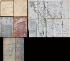
![History of the Expedition under the Command of Captains Lewis and Clark, to the Sources of the Missouri Thence across the Rocky Mountains and Down the River Columbia to the Pacific Ocean, Performed During the Years 1804-5-6 [with map:] Map of Lewis and Clark's Track, Across the Western Portion of North America from the Mississippi to the Pacific Ocean](https://storage.googleapis.com/raremaps/img/small/92506.jpg)
![[California / Washington / Oregon] Pacific Highway Maps](https://storage.googleapis.com/raremaps/img/small/89058.jpg)