
The item illustrated and described below is sold, but we
have another example in stock. To view the example which
is currently being offered for sale, click the
"View Details" button below.
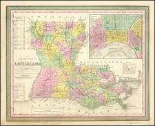
1854 Thomas, Cowperthwait & Co.
$ 225.00


|
||

|

|
|

|
Stock# 88323
Description
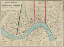
Detailed and interesting map of Louisiana, hand colored by parish, from Thomas, Cowperthwait & Co.'s New Universal Atlas.
The map is one of the best commercial atlas maps of Louisiana published during the period, showing towns, rivers, bays, lakes, railroads, swamps, etc. Table of Steam Boat routes and distances. Large inset map of New Orleans, colored by wards.
![[ New Orleans, Louisiana / Southern Travel Letter ] Lyman Adams letter to Austin Adams, December 21, 1839](https://storage.googleapis.com/raremaps/img/small/96629.jpg)
![[Louisiana / British Emigration -- 5 Maps] Land District North of the Red River in the State of Louisiana / District North of the Red River Louisiana / Land District North of the Red River, State of Louisiana / Township 20 N. Range 13 East, Land District North of the Red River in the State of Louisiana / A Map, exhibiting the order oft he Surveys of the Public Lands of the United States of North America . . . .](https://storage.googleapis.com/raremaps/img/small/90084.jpg)