|
||

|

|
|

|
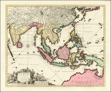
Nice example of James Rennell's highly detailed map of Eastern India, based upon his survey work while Surveyor General of the East Indian Company.
The map is exceptionally detailed and includes roads, towns, mountains, rivers and a host of other details. One of the most important maps of India from the period.
James Rennell is widely considered to be the most important and influential map maker of 18th century India. Rennell was appointed surveyor-general of Bengal in 1764, at the age of twenty-one. His first great work, "The Bengal Atlas", came out in 1779. It contained 21 maps and plans. He also created maps of the provinces as Behar, Bengal, Delhi, Agra, Oude and Allahabad.
Laurie & Whittle
Robert Laurie (ca. 1755-1836) and James Whittle (1757-1818) formed their Fleet Street, London-based firm upon the 1794 death of their employer Robert Sayer, himself one of the dominant print and mapmakers of the last half of the 18th century.
Laurie & Whittle started managing Sayer's business as early as 1787. They took over all managerial duties when Sayer's health flagged in 1792, and they changed the imprint in 1794 upon his death. Sayer left the two a 21-year lease on the shop (at £100 a year) and on Sayer's Bolt Court premises, as well as an option to acquire stock and equipment at a preferential price of £5,000 payable over three years.
Robert Laurie retired from the firm in 1812, and his role was assumed by his son, Richard Holmes Laurie (1777-1858). The younger Laurie worked with James Whittle until the latter died in 1818. After R. H. Laurie died in 1858, Alexander George Findlay, FRGS (1812-1875) purchased the firm from his daughters. The firm continues today under another name, specializing in yachting charts.
Laurie & Whittle were prolific print and map publishers, and throughout their careers, they produced numerous very important and rare works. They carried on Robert Sayer's atlas business and were responsible for editions of The Complete East-India Pilot and The American Atlas.
James Rennell
James Rennell (1742-1830) was a pioneering English geographer, historian, and oceanographer. He was responsible for the first approximately accurate map of India and published the Bengal Atlas (1779). Both works were important for British colonial interests in the Subcontinent.
Rennell is best known for his survey of India, the first scientific survey of the Subcontinent ever conducted. While serving in the Royal Navy from 1756 to '63, Rennell learned the skills of an expert colonial surveyor. He accompanied Alexander Dalrymple to the Philippines in 1762. Rennell joined the East India Company in India. He served as surveyor general of Bengal (1764-77) and of Bihār and Orissa (1767-77). He left India in 1777, returning to London where he continued to work on geographical research and publishing until his death in 1830.
A General Atlas, describing the Whole Universe [1797]
This map comes from Thomas Kitchin's A General Atlas. This atlas was conceived of by Thomas Jefferys in the 1760s. Following Jefferys' bankruptcy in 1766, the atlas was first completed by Robert Sayer in 1773. This was Robert Sayer's first terrestrial atlas. From 1794 the atlas was published by his successors Laurie & Whittle. Later editions tend to be more desirable. Thomas Kitchin's name appears on title pages even after his death in 1784. The maps are after a variety of makers such as d'Anville, Roberts, Dunn, Rocque, Delarochette, Rennell, Zannoni, Dury, Cook, Vancouver, Perouse and others.
This map is from the 1797 edition of the atlas. This atlas was later expanded and replaced by Laurie & Whittle's A New Universal Atlas.
Robert Laurie (ca. 1755-1836) and James Whittle (1757-1818) formed their Fleet Street, London-based firm upon the 1794 death of their employer Robert Sayer, himself one of the dominant print and mapmakers of the last half of the 18th century.
Laurie & Whittle started managing Sayer's business as early as 1787. They took over all managerial duties when Sayer's health flagged in 1792, and they changed the imprint in 1794 upon his death. Sayer left the two a 21-year lease on the shop (at £100 a year) and on Sayer's Bolt Court premises, as well as an option to acquire stock and equipment at a preferential price of £5,000 payable over three years.
Robert Laurie retired from the firm in 1812, and his role was assumed by his son, Richard Holmes Laurie (1777-1858). The younger Laurie worked with James Whittle until the latter died in 1818. After R. H. Laurie died in 1858, Alexander George Findlay, FRGS (1812-1875) purchased the firm from his daughters. The firm continues today under another name, specializing in yachting charts.
Laurie & Whittle were prolific print and map publishers, and throughout their careers, they produced numerous very important and rare works. They carried on Robert Sayer's atlas business and were responsible for editions of The Complete East-India Pilot and The American Atlas.
![[Northwestern India & Pakistan] Tabula Asiae IX](https://storage.googleapis.com/raremaps/img/small/46402.jpg)