
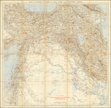
![(Second World War - Oilfields) Vorderasien mit seinen Erdölgebieten [Western Asia with Its Oil Fields] By Velhagen & Klasing](https://storage.googleapis.com/raremaps/img/small/87373.jpg)


|
||

|

|
|

|
Important and very unusual German language map of the Middle East, southern Soviet Union, and parts of Central Asia, illustrating their strategic importance (primarily by virtue of their oil supplies) during the Second World War.
In the increasingly mechanized warfare of World War II, access to oil was the impetus and deciding factor in several conflicts. This map, which was published in Germany in 1941, illustrates the vast oilfields of Iran, the Caucusus, and the Capsian Basin, with most of the biggest oilfields in the Middle East (outside of Bahrain) still unexplored and unknown.
Historians consider Germany's desire to secure access to the oil depicted on this map (and its desire to deny that oil to the Soviet Union) as one of the motivating factors in the ill-fated attack on Stalingrad.
The key mentions, among other things:
Steinkohle [Coal]
Erdöl [Oil]
Erdölleitung [Oil pipeline]
Eisenerz [Iron ore]
Kupfer [Copper]
Kriegshafen [Naval port]
As a map of oil resources in the Middle East from the early 1940s, as well as an illustration of the petroleum-related motives of German military strategy, this item is highly unusual.

![L. Rouwolfs Reys-Togten, door de Levant, of Oosterse Landschappen der Middellandse Zee [shows Cyprus]](https://storage.googleapis.com/raremaps/img/small/83622.jpg)