|
||

|

|
|

|
Stock# 88208
Description
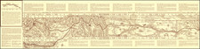
Interesting pictorial map of the route of the Northern Pacific "Empire Builder" railway, from Chicago, through the Twin Cities, and out across the plains and Rockies to the Pacific Northwest.
The map was made around 1965 (the "565" numbering and 1960 Federal Census data seem to confirm this), but harkens back to an early era of railroad mapmaking.
Condition Description
Folding map printed on both sides.
![Map of Oregon Territory. By Samuel Parker. 1838. [with:] Journal of an Exploring Tour Beyond the Rocky Mountains, under the direction of the A. B. C. F. M. 1840.](https://storage.googleapis.com/raremaps/img/small/97939.jpg)