
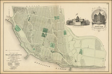
![[ Battle of Saratoga -- Multi Day Flap ] Plan of the Encampment and Position of the Army under His Excelly. Lt. General Burgoyne at Braemus Heights on Hudson's River near Stillwater, on the 20th Septr. with the Position of the Detachment &c. in the Action of the 7th of Octr. & the Position of the Army on the 8th Octr 1777. Drawn by W.C. Wilkinson Lt. 62 Regt. Asst. Engr. [with the overlaid flap] By William Faden](https://storage.googleapis.com/raremaps/img/small/102532.jpg)


|
||

|

|
|

|
Detailed engraved battle plan of the end stages of the Battle of Saratoga, showing the maneuvers of British and American troops west of Bennington and north of Albany in the Hudson River Valley in upstate New York.
The map was engraved by William Faden after a manuscript by W.C. Wilkinson. It sports an onlaid engraved flap allowing the map to communicate changes in troop positions over time. The flap shows the positions to which Burgoyne's army retreated on the 8th of October 1777.
This shows the closing stages of the Battle of Saratoga. General Burgoyne attacked Bemis Heights (here called "Braemus Heights") on October 7 after it became apparent that he would not receive relieving aid from Sir Henry Clinton in time. This battle culminated in heavy fighting marked by General Arnold's spirited rallying of the American troops. Burgoyne's forces were thrown back to the positions that they held before the September 19 battle, and the Americans captured a portion of the entrenched British defenses.
Burgoyne would be surrounded and outnumbered 3-to-1 after this battle and on the 17th of October he surrendered to the American General Gates.
This map appeared in John Burgony's A state of the expedition from Canada. 1780.
William Faden (1749-1836) was the most prominent London mapmaker and publisher of the late-eighteenth and early-nineteenth centuries. His father, William Mackfaden, was a printer who dropped the first part of his last name due to the Jacobite rising of 1745.
Apprenticed to an engraver in the Clothworkers' Company, he was made free of the Company in August of 1771. He entered into a partnership with the family of Thomas Jeffreys, a prolific and well-respected mapmaker who had recently died in 1771. This partnership lasted until 1776.
Also in 1776, Faden joined the Society of Civil Engineers, which later changed its name to the Smeatonian Society of Civil Engineers. The Smeatonians operated as an elite, yet practical, dining club and his membership led Faden to several engineering publications, including canal plans and plans of other new engineering projects.
Faden's star rose during the American Revolution, when he produced popular maps and atlases focused on the American colonies and the battles that raged within them. In 1783, just as the war ended, Faden inherited his father's estate, allowing him to fully control his business and expand it; in the same year he gained the title "Geographer in Ordinary to his Majesty."
Faden also commanded a large stock of British county maps, which made him attractive as a partner to the Ordnance Survey; he published the first Ordnance map in 1801, a map of Kent. The Admiralty also admired his work and acquired some of his plates which were re-issued as official naval charts.
Faden was renowned for his ingenuity as well as his business acumen. In 1796 he was awarded a gold medal by the Society of Arts. With his brother-in-law, the astronomer and painter John Russell, he created the first extant lunar globe.
After retiring in 1823 the lucrative business passed to James Wyld, a former apprentice. He died in Shepperton in 1826, leaving a large estate.
![[Massachusetts Bay, with Boston and Part of Cape Cod]](https://storage.googleapis.com/raremaps/img/small/59282.jpg)
![(American Revolution) [Original manuscript account book kept by John Agnew, Clerk of the Quarter Sessions and Justice of the Peace, Cumberland County, Pennsylvania, recording sales of supplies destined for Washington's army during the American Revolution]](https://storage.googleapis.com/raremaps/img/small/95483.jpg)