


|
||

|

|
|

|
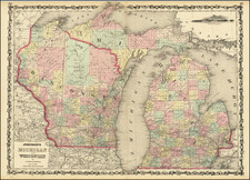
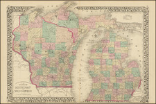
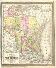
Interesting early map of Wisconsin, which is beginning to show most of its counties.
The lands south of the Wisconsin and Fox Rivers are largely surveyed and many early counties, towns, etc., appear. The region to the north is dominated by larger counties, including newly added Lacrosse, Marathon, and Oconto, each added in the past few years, and La Point, Portage, Chippewa, Polk, Pierce, and St. Croix. These counties were previously the lands of the Winnebagos, Menomonie, Oneidas, Sioux, and Chippewa.
The Carver claim is finally removed in the past few years, after nearly 100 years. The south is filled with roads, and towns, the northern rivers, portages, etc. Significant changes are shown between 1850 and this edition. This edition post-dates the creation of Clark County, Trempealeau County, which was created in January, 1854 and Monroe County, which was created in March, 1854, but does not show Winnebago County, which was created in February 1854.
One of the best early maps of Wisconsin in full original color.