|
||

|

|
|

|
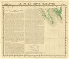
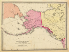
Nice example of George Vancouver's chart of the coast of Alaska centered on Cook Inlet and extending south to Kodiak Island and Trinity Isles. The tracks of Vancouver's 1794 voyage on the HMS Discovery are shown with anchorage dates. Soundings are marked in fathoms. Chartmaker and 3rd Lieutenant Joseph Baker on the ship illustrated the voyage, which was engraved for Vancouver's Voyage of Discovery to the North Pacific Ocean, Volume III.
The Kenai Peninsula was Vancouver's first stop in Alaska after setting sail from Hawaii on March 15th, 1794, reaching land on April 3rd.
The map includes a handful of places named by the Discovery crew, such as Point Woronzow, after the Russian Ambassador in Britain, Point Mackenzie, after James Stuart Mackenzie, and Point Campbell.
Two Russian fur-trading posts, in Fort Nikolaevskaia (or Kenai) and Tyonek, are mapped.
George Vancouver (1757–1798), a naval officer and explorer, grew up in King’s Lynn, England, the youngest of six children. After entering the Royal Navy in 1771, he served in both the second and third great exploratory voyages of James Cook. During Cook’s second voyage, a three-year quest to find a legendary southern continent, Vancouver received instruction from the astronomer William Wales. During Cook’s third voyage, to the Pacific Northwest, Vancouver was part of the first known group of Europeans to land on the coast of present-day British Columbia.
Vancouver gained valuable navigational, surveying, and mapping experience in the Pacific Northwest during his time with Cook. After returning from Cook’s third voyage in 1780, Vancouver was promoted to lieutenant and spent the following nine years serving on fighting ships, primarily in the Caribbean.
In 1790, Vancouver was chosen to captain the Discovery and charged with a mission to discover and chart the vast areas of the Pacific that were still unknown, in part to locate a Northwest Passage between the Atlantic and Pacific Oceans. This four-year voyage of discovery circumnavigated the globe and eliminated the possibility of an inland Northwest Passage. During many months of surveying, Vancouver produced detailed regional maps of the Northwest Coast, as far north as Alaska. He also established several hundred place-names for physical features in the areas surveyed.
Upon returning to England in 1795, Vancouver’s voyage received little recognition, and he faced personal and political attacks from colleagues and crew members alleging abuse of power. With his health failing, Vancouver spent his remaining years in retirement, revising his journal for publication. His Voyage of Discovery to the North Pacific Ocean, and Round the World was first published in 1798, which was also the year of his death. It contained a multi-volume account of his voyage as well as an atlas of his maps. His exploration and mapmaking activities greatly increased knowledge of the North American coast.