|
||

|

|
|

|
Across the Wide Pacific
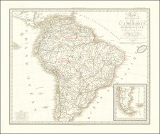
Striking map of the South Atlantic and South Pacific from prominent mapmaker Thomas Jefferys.
This example was reissued by Laurie & Whittle in 1794. It was initially included in The American Atlas: Or, A Geographical Description Of The Whole Continent Of America, which had maps by Thomas Jefferys and was published posthumously by Jefferys’ one-time partner, Robert Sayer, and his collaborator, John Bennett, from 1776.
Much of the detail for the map is patterned after the 1753 map of North and South America by Jefferys’ employee and rouge mapmaker, John Green, a.k.a. Bradock Mead (see below). For example, the tables included in the South Atlantic are directly from Green’s work. There are updates, however, to reflect the recent findings of voyages in the 1760s; for instance, the outline of the Falklands is now complete and the routes included have been changed.
The chart stretches from St. Helena, in the east, to Aotearoa/New Zealand, in the west. It covers the latitudes zero to sixty degrees south.
South America is distinguished by its backbone, the Andes, and the Pampas. As one moves west, they see the cluster of the Society Islands and New Caledonia. Nearby are the “Imaginary Isles of Solomon.”
The Solomon Islands had been visited, supposedly, by Alvaro de Mendaña, on his first Pacific voyage in in 1567-9. His crew forced his return to Peru. Another attempt was made from 1595-6 to return to the Solomons, but they had not been charted accurately, hence the ambiguity shown here. Mendaña died on Santa Cruz, leaving his wife in charge of the settlement they had started. She decided to return to Spanish dominions and they arrived in the Philippines in early 1596. The track of Mendaña’s first voyage is included on this map.
There are many other routes that zig-zag across the waters. Tasman’s approach to Aotearoa/New Zealand is shown. This was part of Tasman’s first Pacific voyage, in 1642, which circumnavigated the continent of Australia by sailing to New Zealand and then, in a large arc, back north to Batavia.
Narbrough’s track approaches the Argentinian coast of Patagonia. Narbrough led the first Royal Navy expedition into the South Seas (1679-1671), although the track here ends at Port Desire. In reality, he sailed south from Port Desire and through the Strait of Magellan to Valdivia. There, he had to abandon four of his men and returned via the Strait to England.
Anson’s track wildly rounds Cape Horn and then crosses the Pacific. On this circumnavigation (1740-1744), he lost five of his six ships and 1,500 of his 1,900 men, but then captured a Spanish treasure galleon.
John Byron sailed with Anson as a midshipman and was shipwrecked in the Wager in Western Patagonia. Twenty-five years later, in 1764, Bryon was secretly dispatched to search for a stopover station in the southwestern Atlantic and then to search for the Northwest Passage. He did contact the Falklands, which sparked controversy with France and Spain, searched for Patagonian giants, passed through the Strait of Magellan, and then zipped across the Pacific, conducting the fastest circumnavigation to that date.
Upon his return to England, his ship and some of this crew, including Philip Carteret, immediately prepared for another voyage, this one public. Samuel Wallis commanded Byron’s Dolphin, while Carteret was to accompany in the Swallow. However, the Swallow was practically un-seaworthy. After a torturous passage through the Strait of Magellan, Wallis and the Dolphin streaked northward, eventually landing at Tahiti, the first European ship to do so. Carteret, now alone, led the Swallow through higher latitudes, one of the first to take such a southerly route across the Pacific.
At the same time that Wallis and Carteret were sailing, the Frenchman Louis Antoine de Bougainville led his own circumnavigation (1766-1769). He called at Tahiti weeks after Wallis and found it idyllic. His description of the island would do much to create the stereotype of the Pacific as an exotic paradise to Europeans.
By the time Wallis returned, another British voyage was already in the planning. This one was to observe the Transit of Venus on 1769, which was particularly visible from the South Seas. Wallis was able to suggest Tahiti as the destination, which was taken up. This would be the inaugural Pacific voyage commanded by James Cook (see below), the first of three. Byron, Wallis, Carteret, Cook (first voyage), and Bougainville all have ships’ tracks on this map.
John Green (Bradock Mead)
John Green is an alias for Bradock Mead (ca. 1688-1757). Raised in Dublin, his brother Thomas, served as Lord Mayor of the city in 1758-9. While in Dublin, he published The construction of maps and globes (London: 1717). He also became involved with a plot to kidnap an heiress. He escaped, but others in his group were not so lucky. He came to London and took on the name Rogers and worked as an amanuensis.
He was active in London from at least the early 1720s to 1755. Later, as Green, he translated du Halde’s Description géographique de la Chine into English for the publisher Edward Cave. He also worked on Astley’s voyage collection. However, he fell out with both men. From the 1730s onward, he worked periodically with Thomas Jeffreys, Geographer to Frederick Price of Wales and later to King George III. In 1757, he committed suicide by jumping from a third-story window.
Cook's first voyage (1768-1771)
The Transit of Venus is one of the rarest predictable astronomical phenomena, occurring twice in eight years and then not again for over one hundred years (in a 243-year cycle). Observing the time it takes for Venus to transit across the sun can help to calculate the size of the solar system and the distance from the Earth to the Sun. In 1761, scientific societies sought to record the Transit from posts around the world. However, many of the observations were flawed or thwarted by the weather, especially those arranged, in haste, by the Royal Society of London. Determined to not repeat the same mistake, the Royal Society planned a South Sea voyage to view the 1769 Transit in concert with the Royal Navy, as the southern Pacific would be one of the places where the Transit was visible.
The Admiralty chose Lieutenant James Cook to command the expedition, based on his aptitude for charting and instrumentation. He was joined by Joseph Banks, a wealthy young botanist, and his retinue of scientists and artists. In addition to observing the Transit, Cook was secretly instructed to seek out and claim any potentially-useful territory or resources that his ship, Endeavour, came across.
Cook and his crew sailed from Plymouth on August 25, 1768. It sailed south, to Tierra del Fuego, and then to its destination for the Transit: Tahiti. There, three groups observed the Transit, although their results were imprecise. When the Endeavour left Tahiti in July 1769; on board was a new member of the party, the Rai’aitean priest and navigator Tupaia, along with his servant, Taiato.
The ship headed south, arriving in New Zealand in early October. There, Tupaia found that he could understand and speak with the local people, the Māori. However, this did not prevent several violent incidents that resulted in deaths. While charting the coastline, Cook and the voyage astronomer, Charles Green, observed the Transit of Mercury. The ship sailed round the southern tip of the South Island, proving it was not connected to a southern continent.
Next, the Endeavour set out east, encountering the east coast of Australia in April 1770. They were the first Europeans to do so. After stopping at a place they called Botany Bay, the ship turned north, skirting the coast. Endeavour ran aground on the Great Barrier Reef; while the ship was saved, they had to stop for repairs at Waalumbaal Birri, or Endeavour River. Here, the Europeans saw their first kangaroo and learned its name from the local people, the Guugu Yimithirr. They nearly ran aground again, but narrowly averted disaster and made for Jakarta, then known as Batavia.
In Batavia, many members of the crew became ill. More than two dozen men, including Sydney Parkinson, the voyage artist, the aforementioned Charles Green, and Tupaia, died in Jakarta or at sea soon thereafter. Weakened, the Endeavour called at the Cape of Good Hope and returned to the Thames in July 1771.
Thomas Jefferys (ca. 1719-1771) was a prolific map publisher, engraver, and cartographer based in London. His father was a cutler, but Jefferys was apprenticed to Emanuel Bowen, a prominent mapmaker and engraver. He was made free of the Merchant Taylors’ Company in 1744, although two earlier maps bearing his name have been identified.
Jefferys had several collaborators and partners throughout his career. His first atlas, The Small English Atlas, was published with Thomas Kitchin in 1748-9. Later, he worked with Robert Sayer on A General Topography of North America (1768); Sayer also published posthumous collections with Jefferys' contributions including The American Atlas, The North-American Pilot, and The West-India Atlas.
Jefferys was the Geographer to Frederick Prince of Wales and, from 1760, to King George III. Thanks especially to opportunities offered by the Seven Years' War, he is best known today for his maps of North America, and for his central place in the map trade—he not only sold maps commercially, but also imported the latest materials and had ties to several government bodies for whom he produced materials.
Upon his death in 1771, his workshop passed to his partner, William Faden, and his son, Thomas Jr. However, Jefferys had gone bankrupt in 1766 and some of his plates were bought by Robert Sayer (see above). Sayer, who had partnered in the past with Philip Overton (d. 1751), specialized in (re)publishing maps. In 1770, he partnered with John Bennett and many Jefferys maps were republished by the duo.

![[The First Maps Printed Color] Cartes en Couleur des Lieux Sujets aux tremblements de Terre Dans toutes les parties du Monde Selon le Sisteme de l’impulsion Solaire](https://storage.googleapis.com/raremaps/img/small/52293op.jpg)