


|
||

|

|
|

|
Stock# 87999
Description
First Edition.
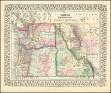
Scarce Gill map of Oregon and Washington Territory (more often the Gill maps focus on one or the other), first published in Portland in 1878.
This beautiful hand-colored lithographed map shows early large county configurations, railroads, and communities.
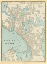
Seattle has only the shortest of railroads connecting the city to Renton and coal mines on the east side of Lake Washington. The map notes the proposed route of the Northern Pacific from Walla Walla.
At the time, Portland, Oregon, was more of a center of commerce and is here shown with long railroad connections through the Willamette Valley, not yet completed to connect to California.
Rarity
Scarce.
![[ Early Automobile Tourism -- Pacific Coast Highways ] (Strip Maps, etc.)](https://storage.googleapis.com/raremaps/img/small/81461.jpg)
![(Nothern Half) [Bancroft's Map of the Pacific States]](https://storage.googleapis.com/raremaps/img/small/54924.jpg)
![[San Francisco to British Columbia] Carta particolare dello stretto di Iezo fra l'America e I'Isola Iezo . . . D'America Carta XXXIII](https://storage.googleapis.com/raremaps/img/small/67788.jpg)