|
||

|

|
|

|
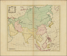
One of the Most Influential Eighteenth-Century Maps of Asia
De L’Isle’s important map of Asia; one of the most detailed maps of the continent then extant, it served as a model for contemporary mapmakers.
This example is a 1745 reissue by De L’Isle’s son-in-law, Philppe Buache, of the 1723 original.
The continent is masterfully rendered, stretching from Turkey and Eastern Africa to Japan, from the Arctic Sea (Mer Glaciale) to the Maldives. Maritime Southeast Asia is well delineated, and the mainland is densely labeled with political units, towns, mountains ranges, and important features like the Great Wall of China.
De L’Isle had been mapping Asia for decades by the time he made this map, and he was continuously improving on his knowledge and refining what he included. For example, as compared to the atlas map of Asia he published in 1700, this map no longer has any reference to L. de Kia in Burma. This Lake Kia, on his 1700 map, was itself a reference to the fabled Lake Chiamay that was often included in the area. It was thought to give rise to four great rivers. However, upon reviewing all the extant sources, De L’Isle reduced the lake’s size and importance. Later, on the present map, he abandoned the feature all together.
Another area that has been updated is the far northeast. On his previous map, De L’Isle had sprinkled toponyms that had to do with “amour,” such as the Mer d’Amour. While the reader might think this refers to a Sea of Love, it is actually a derivation of the nearby R. d’Amour, which is the Amur River. The tenth longest river in the world, the Amur separates Russia and Inner Manchuria. Here, De L’Isle has adopted the correct spelling.
De L’Isle’s erudition did not mean that he did not leave some geographic questions open for interpretation. Nouvelle Zemle, in the Arctic, is unfinished. Hokkaido, in northern Japan, is shown as Terre d’Eso ou d’Yesso, and is part of the mainland, near a boxy Korean Peninsula and the Mer de Corée (which had previously been the Mer Orientale on his earlier Asia map). Yesso nearly touches Terre de la Compagnie, which refers to a series of geographic chimeras that haunted the North Pacific on early modern maps.
The lands near to Terre de la Compagnie are obscured by the elegant title cartouche. There, De L’Isle includes notes about his sources: Jesuit accounts, memoirs from Russia and the Middle East, rutters, and manuscript maps and charts.
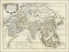
The Mughal Empire, Arakan, and Tonkin
The map carefully lays out the boundaries of the area’s empires and polities, including the Persian Empire, China, and other political entities of India and Southeast Asia like the Mughals, Arakan (here Aracan), and Tonkin. The Mughal Empire began when Babur (r. 1526-1530), originally from Central Asia, established himself in Kabul, Afghanistan and marched south into India via the Khyber Pass. His descendants consolidated power and fought off rivals. Particularly under the rule of Akbar (r. 1556-1605), the Mughal Empire developed an imperial structure characterized by tolerance of religious differences and a competent administrative elite.
Later in the seventeenth century, the Mughal Empire developed not only as a center of arts and culture—the Taj Mahal was built during this time—but as a political and economic power house. By 1707, under the controversial ruler Aurangzeb (r. 1658-1707), the Mughal Empire reached its largest extent, encompassing much of the Indian subcontinent. A decade later, however, the empire entered into decline. Many of the areas that had been added by Aurangzeb were in open revolt and the dynastic line was in chaos. In 1719, four separate emperors ruled. The Mughal Empire began to lose land and influence, particularly in the face of Maratha opposition and the arrival of the British East India Company.
The kingdom of Arakan was an Indianized kingdom nestled between the Indian subcontinent, the Bay of Bengal, and what was historically known as Burma. At a significant crossroads in trade routes to India, China, and Southeast Asia, Arakan was diverse religiously and ethnically. Islam came to the region in the eighth century. The Rakhine people migrated to the area around the ninth century; today, the area is Rakhine State in Myanmar. The area was also a site of conflict, with the Burmese and Bengal Sultanate just some of those who sought to control the strategic and economically-important region. Arakan was able to survive and had a formidable navy by the seventeenth century.
However, the Dutch and the Portuguese were also drawn to the trade center. The Dutch arrived in 1623; thirty years later, they completed a treaty that gave the Dutch East India Company duty-free trade rights. However, in 1665 the Mughals smashed the Arakan fleet, forcing the area into decline.
Tonkin (also Tongkin, Tonquin, Tongking) refers to the northern part of what is today Vietnam. It means “eastern capital,” in reference to Hanoi. In the first millennium CE, the area for a time was under the control of China. After 938, however, it was independent and ruled by the Ngô, Đinh, Early Lê, Lý, Trần, and Hồ dynasties. Disputes with China continued, with Lê Lợi as a notable leader who fought the Ming dynasty and established himself in Hanoi in the mid-fifteenth century. By the seventeenth century, Westerners were frequent visitors to the area. They traded with the Trinh lords who were then in power. The French took the area as a protectorate from 1884 to 1945.
The Kingdom of Siam
Perhaps the most famous kingdom shown on the map is that of Siam, or Thailand. In the Medieval period, several polities consolidated and vied for power. One of these was the Sukhothai Kingdom, which was a kingdom that arose in the mid-thirteenth century. Another kingdom, Ayutthaya, came to prominence in the late fifteenth century, when it challenged the Khmer Empire for dominance in the area, subjugating other entities, including Sukhothai, in the process.
Europeans encountered the kingdom in the early sixteenth century, when the Portuguese Duke Afonso de Albuquerque sent an envoy to King Rama Thibodi II. They became allies, helping the Portuguese to expand in Southeast Asia. A century later, the French, Dutch, and English had also met with court officials and competed for favor. After a power struggle with the Burmese, the Ayutthaya emerged even stronger. Europeans hailed the kingdom as a great power with immense wealth, especially during the reign of Narai (1656-1688). However, fears of French influence in particular fed an uprising against Narai at the end of his reign called the Siamese Revolution of 1688.
Relations with Europeans remained relatively stable thereafter, but internal power struggles continued. Neighboring states took advantage of this turmoil and the Burmese toppled the capital city in 1767. However, a local leader, Chao Tak, took back the city only seven months later. Chao Tak expanded the new Thonburi Kingdom’s territory, but a coup against him led to the rise of the Chakri Dynasty in 1782.
In the nineteenth century, a series of leaders tried to modernize Siam while keeping it independent of European imperial ambitions. They were successful in the sense that Thailand was not formally colonized, but they were subjected to unfair treaties by Western nations. This period is well known because of the musical “The King and I,” which is based on a novel by Margaret Landon which in turn is based on the memoirs of Anna Leonowens, who taught the wives and children of King Mongkut in the 1860s.
North Pacific chimeras: Yesso, De Gama, and Compagnie Land
The etymology of the idiom Yesso (Eso, Yeco, Jesso, Yedso) is most likely the Japanese Ezo-chi; a term used for the lands north of the island of Honshu. During the Edō period (1600-1886), it came to represent the ‘foreigners’ on the Kuril and Sakhalin islands. As European traders came into contact with the Japanese in the seventeenth century, the term was transferred onto European maps, where it was often associated with the island of Hokkaido. It varies on maps from a small island to a near-continent sized mass that stretches from Asia to Alaska.
The toponym held interest for Europeans because the island was supposedly tied to mythic riches. Father Francis Xavier (1506-1552), an early Jesuit missionary to Japan and China, related stories that immense silver mines were to be found on a secluded Japanese island; these stories were echoed in Spanish reports. The rumors became so tenacious and tantalizing that Abraham Ortelius included an island of silver north of Japan on his 1589 map of the Pacific.
Yesso is often tied to two other mythical North Pacific lands, Gamaland and Compagnies Land. Juan de Gama, the grandson of Vasco de Gama, was a Portuguese navigator who was accused of illegal trading with the Spanish in the East Indies. Gama fled and sailed from Macau to Japan in the later sixteenth century. He then struck out east, across the Pacific, and supposedly saw lands in the North Pacific. These lands were initially shown as small islands on Portuguese charts, but ballooned into a continent-sized landmass in later representations.
Several voyagers sought out these chimerical islands, including the Dutchmen Matthijs Hendrickszoon Quast in 1639 and Maarten Gerritszoon Vries in 1643. Compagnies Land, often shown along with Staten Land, were islands sighted by Vries on his 1643 voyage. He named the islands for the Dutch States General (Staten Land) and for the Dutch East India Company (VOC) (Compagnies, or Company’s Land). In reality, he had re-discovered two of the Kuril Islands. However, other mapmakers latched onto Compagnies Land in particular, enlarging and merging it with Yesso and/or Gamaland.
In the mid-eighteenth century, Vitus Bering, a Danish explorer in Russian employ, and later James Cook would both check the area and find nothing. La Perouse also sought the huge islands, but found only the Kurils, putting to rest the myth of the continent-sized dream lands.
Guillaume De L'Isle (1675-1726) is probably the greatest figure in French cartography. Having learned geography from his father Claude, by the age of eight or nine he could draw maps to demonstrate ancient history. He studied mathematics and astronomy under Cassini, from whom he received a superb grounding in scientific cartography—the hallmark of his work. His first atlas was published in ca. 1700. In 1702 he was elected a member of the Academie Royale des Sciences and in 1718 he became Premier Geographe du Roi.
De L'Isle's work was important as marking a transition from the maps of the Dutch school, which were highly decorative and artistically-orientated, to a more scientific approach. He reduced the importance given to the decorative elements in maps, and emphasized the scientific base on which they were constructed. His maps of the newly explored parts of the world reflect the most up-to-date information available and did not contain fanciful detail in the absence of solid information. It can be fairly said that he was truly the father of the modern school of cartography at the commercial level.
De L’Isle also played a prominent part in the recalculation of latitude and longitude, based on the most recent celestial observations. His major contribution was in collating and incorporating this latitudinal and longitudinal information in his maps, setting a new standard of accuracy, quickly followed by many of his contemporaries. Guillaume De L’Isle’s work was widely copied by other mapmakers of the period, including Chatelain, Covens & Mortier, and Albrizzi.
Philippe Buache (1700-1773) was one of the most famous French geographers of the eighteenth century. Buache was married to the daughter of the eminent Guillaume Delisle and worked with his father-in-law, carrying on the business after Guillaume died. Buache gained the title geographe du roi in 1729 and was elected to the Academie des Sciences in the same year. Buache was a pioneering theoretical geographer, especially as regards contour lines and watersheds. He is best known for his works such as Considérations géographiques et physiques sur les découvertes nouvelles dans la grande mer (Paris, 1754).
![The Map of China [Huang Ming yitong fang yu bei lan -- Comprehensive view map of the Imperial Ming]](https://storage.googleapis.com/raremaps/img/small/99110.jpg)
![[Rare Complete Example with Game Pieces] Grand Circuit Des Capitales. Collection Concours Du Chocolat Menier](https://storage.googleapis.com/raremaps/img/small/70922rd.jpg)