|
||

|

|
|

|
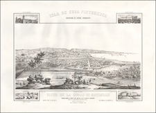
Rare Map of Havana (Cuba) first published by Pierre Mortier in 1702, during the War of Spanish Succession.
The map features the city and harbor of Havana, Cuba.
Founded in 1513, Havana had become a sizeable city that was considered the be the most 'European' and sophisticated city in the Americas. The large natural harbor is shown to be guarded by the Velha Fort and the Moro Fort (the latter a great stone edifice built in 1589). During the time that this map was made, the city's distinctive city walls were in the process of being built. Havana was critically important, as it was the final terminus for the Spanish galleons before they transited the Atlantic for Spain. Always a key target for the British, it was not successfully besieged until 1762.
Th map was originally issued as part of a set of three harbor maps which appeared in Pierre Mortier's Les forces de 'Europe, Asie, Afrique et Amerique ou description des principales villes, avec leurs fortifications... (Amsterdam in 1702).
Pierre, or Pieter, Mortier (1661-1711) was a Dutch engraver, son of a French refugee. He was born in Leiden. In 1690 he was granted a privilege to publish French maps in Dutch lands. In 1693 he released the first and accompanying volume of the Neptune Francois. The third followed in 1700. His son, Cornelis (1699-1783), would partner with Johannes Covens I, creating one of the most important map publishing companies of the eighteenth century.
![(Cuba - Includes Havana Harbor) Paskaert vande Noord Cust van Cuba Streckende van Bahia de Matancas to Bahia Honda. Beschreven door Roggeveen . . . [Chart of the North Coast of Cuba, Stretching from Matanzas Bay to Honda Bay. Described by Roggeveen...]](https://storage.googleapis.com/raremaps/img/small/63760.jpg)
![[War of Jenkins Ear in Florida and West Indies] [Harbors, Towns & Fortresses of North America, St. Augustine, Providence (Grand Bahama Island), Porto Antonio (Jamaica), Havana, Santiago (Cuba), Kingston, and Antiqua)]](https://storage.googleapis.com/raremaps/img/small/75642.jpg)