This item has been sold, but you can enter your email address to be notified if another example becomes available.


|
||

|

|
|

|
Stock# 87864
Description
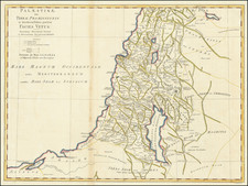
Interesting early-19th-century English map of Jerusalem and the surrounding countryside, published by Robert Wilkinson.
The map includes plans of Jerusalem, Bethlehem, Gideon, and the other nearby towns. In the lower right is a key with over twenty place names. The level of detail, and in particular the focus on roads, makes this a particularly nice example of a popular mapping of the Holy City. Biblical places are named.
"Moriah" is the name given to a mountainous region in the Book of Genesis. According to Jewish sources, Mount Moriah is in the vicinity of modern-day Jerusalem.
This map was later reproduced by Finley for his New General Atlas.
Condition Description
Fine original hand-color.

![[Heightened with Gold Leaf! -- Paul's Travels ] De Reysen Christi Des Heyland en Pauli met andere syne Bloedgetuygen](https://storage.googleapis.com/raremaps/img/small/72900.jpg)