|
||

|

|
|

|
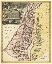
Stock# 87770
Description
Interesting untitled map of the Holy Land from an 18th-century German school atlas.
The map is mostly in German though there is Hebrew used to describe the Mediterranean: "ים הגדול Das Grosse oder Mittellaen-Dische Meer"
The map shows topography, drainage, and the territorial boundaries of the Twelve Tribes of Israel, as well as places of historical interest.
Condition Description
Original hand-color.
![[ Biblical Names for Palestine ]. Carte de La Palestine Ancienne et Moderne avec le Sud du Liban et de l'Anti-Liban et les régions situées à l'est du Jourdain et de la Mer Morte, pour servir à l'étude de la Bible par A. Legendre [Map of Ancient and Modern Palestine with Southern Lebanon and Anti-Lebanon and the regions east of the Jordan and the Dead Sea, for use in the study of the Bible by A. Legendre]](https://storage.googleapis.com/raremaps/img/small/85737.jpg)
![[Holy Land] Syria](https://storage.googleapis.com/raremaps/img/small/82757.jpg)