


|
||

|

|
|

|
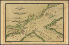
Rare Revolutionary War battle plan of Quebec City, published in London in 1792.
This is the map which Charles Smith would copy for his map of Quebec in the Monthly Military Repository, the first map of Quebec printed in the United States.
The map describes the unsuccessful American attack on Quebec in the winter of 1775-1776. This small plan provides a surprisingly rich view of the city and includes streets, fortifications, some individual buildings, and even gardens. The legend in the lower left identifies thirty landmarks throughout the city.
The map appeared in John Trusler's rare 20 volume work, The habitable world described, or The present state of the people in all parts of the globe, from north to south; shewing the situation, extent, climate,... including all the new discoveries... With a great variety of maps, published in London between 1788 and 1797.
This plan seldom appears on the market.
![[ Siege of Quebec ] Quebek, De Hoofdstad van Kanada; aan de Rivier van St. Laurens . . . 1759](https://storage.googleapis.com/raremaps/img/small/93087.jpg)
![[Boston / Anapolis Royal / Plaisance] Plans des Isles, Rades, et Ports de plusieurs Lieuxde l'Amerique Tires de la Carte Angloises de Mr. Popple publiee en 1733 a Londres en Vingt Feuilles.](https://storage.googleapis.com/raremaps/img/small/85117mb.jpg)