|
||

|

|
|

|
Massive Michigan Territory
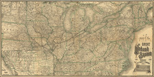
Rare large format map of the United States, published by Anthony Finley in Philadelphia in 1828, and engraved by J. H. Young.
Vance's map provides a fine look at the United States and Western Territories east of the Mississippi River, shortly after the creation of Arkansas Territory (created as an unorganized Territory 1819-1836) and the State of Missouri (1821). The map also shows Michigan Territory at at time when the North West Territory (later Wisconsin Territory) was "attached to Michigan" (1818-1833).
The map is one of the few large format map to illustrate the Military Bounty Lands in northern Missouri and western Illinois.
The treatment of the early Indian Tribes which inhabited Arkansas Territory is quite advanced, with "Indian Boundary" and "Cherokee Boundary Line" shown, Clermo's Band of Osage Indians located and a Missionary Station in the north. Major tribes are also located in Mississippi, Alabama and Georgia.
In the Western Part of Michigan, there are still no organized counties, with only 12 counties in the entire territory. Carey's Missionary Station is shown, created shortly after Governor Lewis Cass signed the Treaty of Chicago in 1821. The mission was established by Baptist missionary Isaac McCoy among the Potawatomi tribe of American Indians on the St. Joseph River near Niles, Michigan, in December, 1822. It was named for William Carey, a noted English Baptist missionary. The Carey Mission's official nature and reputation made it a headquarters for settlers and a point from which the American frontier was extended.
Includes a fine large format inset map showing all of North America, and good treatment of Upper Canada, at the time when the region was seen a growing number of settlers from Scotland, England and the northern United States.
A large table locate describes the principal steamboat routes at the top, with statistical tables at the bottom left.
This is the second state of the map, which was first published in 1825.
Rarity
The map is scarce on the market, especially the 1828 state of the map.
Anthony Finley (1784-1836) was an American map publisher. Little is known about his life. He is presumed to have been born in Philadelphia, where he also died. A publisher, Finley was also involved in several Philadelphia civic and professional societies such as the Philadelphia Apprentices’ Library. He may have been in business as early as 1809 and his first publication dates from ca. 1811.
His first maps also date from this year, with two maps in Daniel Edward Clarke’s Travels in Various Countries of Europe, Asia, and Africa. The first atlas published by Finley appeared in 1818, the Atlas classica, or, Select maps of ancient geography, both sacred and profane, for the use of colleges and schools in the United States. He is best known for his A New General Atlas Comprising a Complete Set of Maps (1824), which was a bestseller. There were two editions in 1824, with annual editions until 1834.
Finley was part of the first generation of American publishers who produced high quality, precise maps on American soil. He was in competition with other Philadelphia publishers, for example Henry S. Tanner. Finley’s A New American Atlas Designed Principally to Illustrate the Geography of the United States of America (1826) closely mirrors Tanner’s A New American Atlas Containing Maps of the Several States of the North American Union, with similar groupings of maps; the main difference is the smaller scale of Finley’s maps. Finley printed two editions of this atlas.