


|
||

|

|
|

|
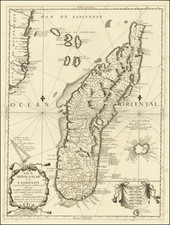
West Coast of Madagascar
Finely executed chart of the west coast of Madgascar, published by Laurie & Whittle
The map shows the are from Cape St. Andrews in the north to the Bays of Saint Augustin and Tullea (Tulear) Bay in the south.
The large inset view includes the area around Morondava.
The chart covers part of the modern day Atsimo-Andrefana Region from Toliara to Saint Augustin and Soalara in the district of Toliara II. The mouth of the Darmouth or Onilahy River is also noted. The map also includes 5 profile views, showing approaches to the harbors.
Robert Laurie (ca. 1755-1836) and James Whittle (1757-1818) formed their Fleet Street, London-based firm upon the 1794 death of their employer Robert Sayer, himself one of the dominant print and mapmakers of the last half of the 18th century.
Laurie & Whittle started managing Sayer's business as early as 1787. They took over all managerial duties when Sayer's health flagged in 1792, and they changed the imprint in 1794 upon his death. Sayer left the two a 21-year lease on the shop (at £100 a year) and on Sayer's Bolt Court premises, as well as an option to acquire stock and equipment at a preferential price of £5,000 payable over three years.
Robert Laurie retired from the firm in 1812, and his role was assumed by his son, Richard Holmes Laurie (1777-1858). The younger Laurie worked with James Whittle until the latter died in 1818. After R. H. Laurie died in 1858, Alexander George Findlay, FRGS (1812-1875) purchased the firm from his daughters. The firm continues today under another name, specializing in yachting charts.
Laurie & Whittle were prolific print and map publishers, and throughout their careers, they produced numerous very important and rare works. They carried on Robert Sayer's atlas business and were responsible for editions of The Complete East-India Pilot and The American Atlas.
![[Jamestown, Saint Helena] Plan de la Forteresse et Bourg, De L'Isle De St. Helene](https://storage.googleapis.com/raremaps/img/small/77017.jpg)
![[Diego Garcia / Chagos Archipelago] Track of the Calcutta East Indiaman, over the Bassas de Chagas, in the Indian Ocean](https://storage.googleapis.com/raremaps/img/small/66729.jpg)
![[ Madagascar ] Carte Particuliere de l'Isle Dauphine ou Madagascar et St. Laurens . . .](https://storage.googleapis.com/raremaps/img/small/52606.jpg)