


|
||

|

|
|

|
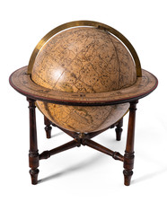
19th-Century American Floor Globe with Original Stand.
Handsome and rare example of a Joslin floor globe. This beautiful piece was produced in Boston by the firm of Gilman Joslin and copyrighted by Charles Copley.
The globe preserves an impressive world map from the latter part of the 19th century, showing the continuously changing political borders of the time. The effects of European colocalization in Africa can be seen, with France, Britain, and other countries claiming a large part of the region. The geography of the US is mostly similar to a present-day map, with some minor adjustments still to be made in Idaho and Oklahoma.
The globe was first issued in 1852, but the present example dates from the latter part of the 19th century.
The globe was updated to show the first Transatlantic Cable, stretching from Newfoundland to Ireland, which was laid in 1858.
Dating
The map shows the Congo Free State and Yellowstone National Park, but shows the independence of the Orange Free State, dating the map to the late 1880s or 1890s. Further, the retention of the Joslin name suggests that the globe was manufactured before his death in 1886.
Gilman Joslin and Globe-Making
Gilman Joslin first started making globes for Josiah Loring in the 1830s and took the reigns of the latter's firm in 1839. Joslin's firm soon became one of America's most prolific globe makers and helped root the industry in the US. Previously, globes sold by most firms had been imported from London, but this practice was changed by Joslin.
Joslin was joined by his son William B. Joslin in 1874, and the firm operated after Gilman Joslin's death as "Gilman Joslin & Son" until 1907.
![[ Astronomical Devices ]](https://storage.googleapis.com/raremaps/img/small/102954.jpg)
![[Second World War-era Japanese Pencil Sharpener Map of the World]](https://storage.googleapis.com/raremaps/img/small/84609.jpg)
![[World -- Terrestrial Globe Gores]](https://storage.googleapis.com/raremaps/img/small/89195.jpg)
![[Parts for a Klinger globe]](https://storage.googleapis.com/raremaps/img/small/46375.jpg)