


|
||

|

|
|

|
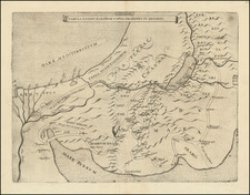
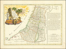
Fine original antique Italian map of the Holy Land, published in Venice in 1783.
The map shows the Holy Land in full, with detail naming the places of importance including cities, towns, rivers, and more. The Twelve Tribes are named. Three inset maps are provided, including one of Jerusalem, one showing the exact delimitation of the regions thought to be controlled by each of the Tribes of Israel, and one showing the distances between major cities in the region.
This map was published as part of Paolo Santini's Atlas Universel, issued by the Remondini firm. The map follows the Vaugondy and D'Anville French mapping of the region.
Paolo Santini (1729-1793) was an Venetian engraver known especially for his religious prints and fine cartographic engravings. He published in Venice and may have a been a member of the clergy. In his maps, he largely adopted and adapted the work of his French counterparts, especially the brothers de Vaugondy.
![[The Travels of Paul] Tabula Geographica, in qua omnes regiones, urbes, oppida, et loca describuntur, quorum mentio fit in Actis et Epistolis Apostolotum, et Apocalypsi; de integro multis in locis emendata, ac regionum limitibus distincta, auct. Pet. Planc. . . .](https://storage.googleapis.com/raremaps/img/small/77970.jpg)