
This item has been sold, but you can enter your email address to be notified if another example becomes available.


|
||

|

|
|

|
Stock# 87667
Description
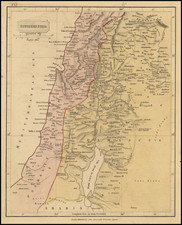
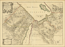
Fine detailed map of the Holy Land, published in Germany in 1851 as part of Stieler's Hand-Atlas.
The map is highly detailed following the German mid-19th century tendency. German maps from this period were notable for their increased level of precision and their basis in on-the-ground surveys. This map is also notable for its focus on archeological results.
The map includes a total of five insets. Two insets show Jerusalem at different periods during its history. One shows the vicinity of Jerusalem. A further two show the regional context of the Holy Land.
Condition Description
Original hand-color. Minor dampstain in the upper left.
![Constantinoplen en Egypten door Nicolaus Schmidt in enn zes Jarige Reystogt uyt Duytsland [shows Cyprus]](https://storage.googleapis.com/raremaps/img/small/57615.jpg)