


|
||

|

|
|

|
Stock# 87639
Description
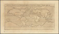
19th-century engraving of a Arabic Mappa Mundi held by the Bodleian Library in Oxford.
The map shows a classic Mappa Mundi layout, with a somewhat well-defined Mediterannean and Near East Region, but increasingly erroneous cartography further away. Many fantastic representations are shown, including the sources of the Nile, a foreshortened East Asia, and a wonderfully curved Europe. Many of the world's rivers are named. The three continents are surrounded by a "gloomy ocean," itself ringed by mountains.
This map was published by Francesco Marmocchi in Florence in 1838.
Condition Description
Original hand-color. Very scant soiling. Binding tab at top.
![Planisphere Physique ou l'on voit du Pole Septentrional ce que l'on connoit de Terres et de Mers Avec les Grandges Chaines de Montagnes . . . [Bay or Sea of the West]](https://storage.googleapis.com/raremaps/img/small/98378.jpg)
![Hemisphere Occidental ou du Nouveau Monde . . . [and] Hemisphere Oriental ou de L'Ancien Monde . . . MDCCLXI](https://storage.googleapis.com/raremaps/img/small/64273.jpg)
![[ Ancient World ] Christianographie](https://storage.googleapis.com/raremaps/img/small/80305.jpg)