|
||

|

|
|

|
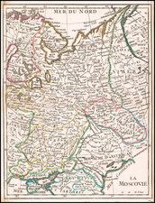
Rare Claes Jansson Visscher map of Russia, based on the manuscripts of Czar Fyodor II Godunov.
A fine map of Russia, drawn from Hessel Gerritsz's map of Russia, published in 1613, with changes.
The map shows that at the beginning of the 17th century, Russia was limited to the northern two-thirds of what is now European Russia, sandwiched in between the Polish-Lithuanian and Swedish empires and the Urals and limited on the south by the Ottoman-controlled Ukraine. Moscow appears almost in the center of the map, while much of the country is shown to be dominated by the Volga watershed, which leaves Russian territory at a point just below Samara. The Arctic coast shows the recent discoveries of the Dutch explorer Willem Barentsz in the 1590s, including Novaya Zemlya.
The top left corner features an inset plan of Moscow that is centered on the Kremlin, Belygorod and the Kityagorod and features a 31 point key (increased from the original 17). The Moscow plan first appeared in print on the original Gerritsz map and proved highly influential, being copied for many decades.
To the right of the map is a view of Archangel, the Arctic port that until the foundation of St. Petersburg (1703), on the Baltic Sea, was Russia's only maritime gateway to the world, which is drawn from the Gerritsz map, with the addition of 4 more views, including Narva, the Kremlin, Hypocausta Russorum and Modendina Russurm.
The map shows Russia as it appeared during the Time of Troubles (1598-1613), an unfortunate and bizarre period of chaos that marked the interregnum between the czars of the Rurik Dynasty and the establishment of the Romanov Dynasty. The period included the 'Dymytirads', the appearance of a succession of individuals fraudulently pretending to be the supposed heir to the Rurik Dynasty, called the 'False Dymytris'. Russia suffered complete political instability, foreign invasion and famine that killed over one-third of the population.
Amazingly, the main map and the inset map of Moscow are attributed to Fyodor II Borisovich Godunov (1589-1605), the ill-fated child genius who was briefly the czar of Russia in 1605. This printed map was compiled from Godunov's manuscript maps brought to Amsterdam by Isaac Abrahamszoon Massa (1586-1643), the Dutch merchant and diplomat who lived in Russia from 1601 to 1609. Massa was an acquaintance of the Fyodor Godunov and perhaps the most reliable eyewitness to the Time of Troubles. He is widely considered to have been the first Western "Kremlinologist".
Visscher's map is exceedingly rare and is one of the most historically important maps of both Russia and Moscow.
![[Spitzbergen & Wiches Lande]](https://storage.googleapis.com/raremaps/img/small/61990.jpg)
![Западное Полушариіе | Восточное Полушаріе [Western Hemisphere | Eastern Hemisphere]](https://storage.googleapis.com/raremaps/img/small/82868.jpg)
![(Ancient Ukraine) Cimmeria quae Postea Scythia Europaea Seu Parua Scythia [Cimmerian, which afterwards became the European Scythia, or the Little Scythia]](https://storage.googleapis.com/raremaps/img/small/82072.jpg)