


|
||

|

|
|

|
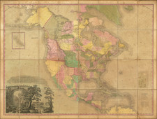
A beautiful example of Nicolas De Fer's rare one-sheet map of eastern North America, based upon his landmark four-sheet map published in 1718.
At the top left of the map is a large-scale map of the Mississippi Delta and Mobile Bay, including information from the 1699 voyage of Pierre Le Moyne d'Iberville. The inset also appears on De L'Isle's 1718 Carte de la Louisiane. D'Ibeville explored the mouth of the Mississippi and its many tributaries, including the Red River in Arkansas. This map was first issued in Volume VI of Chatelain's seven-volume Atlas Historique, published between 1705 and 1720.
Heidenreich and Dahl surmised that the map was issued to promote the recently established Compagnie Francoise Occident and reinforce French opinion in the 1713 boundary settlement. The settlement was initially successful in promoting French emigration to America. However, the financing side of the company, conceived by John Law to help finance the debt left by Louis XIV, led to a wild burst of speculation and ultimate collapse. This episode is often referred to as the Mississippi Bubble. The map includes a nice plan and view of Quebec and fine detail of the Great Lakes and Mississippi. The map includes vignettes and notes throughout and a dozen sailing ships, Indian Villages, etc.
Nicholas de Fer (1646-1720) was the son of a map seller, Antoine de Fer, and grew to be one of the most well-known mapmakers in France in the seventeenth century. He was apprenticed at twelve years old to Louis Spirinx, an engraver. When his father died in 1673, Nicholas helped his mother run the business until 1687, when he became the sole proprietor.
His earliest known work is a map of the Canal of Languedoc in 1669, while some of his earliest engravings are in the revised edition of Methode pour Apprendre Facilement la Geographie (1685). In 1697, he published his first world atlas. Perhaps his most famous map is his wall map of America, published in 1698, with its celebrated beaver scene (engraved by Hendrick van Loon, designed by Nicolas Guerard). After his death in 1720, the business passed to his sons-in-law, Guillaume Danet and Jacques-Francois Benard.


![[Important Early Geology Maps] Tableau du Climat et du Sol des Etats-Unis D'Amérique. Suivi d'éclaircissemens sur la Floride, sur la colonie Française au Scioto, sur quelques Canadiennes et sur les Sauvag . . .](https://storage.googleapis.com/raremaps/img/small/69358.jpg)