


|
||

|

|
|

|
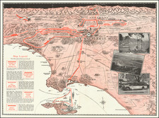
Scarce map of Orange County, California, printed in the mid-1920s and advertising this agricultural part of the state as a place for immigration and investment. The map, published under the auspices of the county board of supervisors, offers a fantastic early rendition of the layout of the county.
The map, set in orange, shows the limited development of Orange County at the time. The disjointed cities shown are Santa Ana, the largest, Anaheim, Fullerton, Huntington Beach, Seal Beach, Laguna Beach, Dana Point, San Juan Capistrano, and San Clemente. Roads go off the map to San Diego (US Highway 101), Elsinore (Ortega Highway), Riverside and San Bernardino (Santa Ana Canyon Road), Pomona (Brea Canyon Road), and many other destinations.
The verso of the map shows the many sites of the region, including the 150-year-old mission at San Juan Capistrano, which dates the map. As expected for early-20th-century Orange County, its agriculture is a primary draw for the county. The average year's yield of oranges is quoted as worth $18 million.

![[ Highway Symbols! ] Automobile Road Map of California-Nevada Los Angeles and Vicinity Long Beach](https://storage.googleapis.com/raremaps/img/small/99652.jpg)