|
||

|

|
|

|
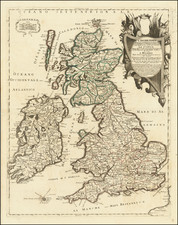
The lower-half of Ortelius's rarest atlas map of the British Isles and Ireland published only between 1590 and 1592, with some remainder copies issued in 1602.
The map shows Ireland in full as well as England and Wales. Cities, rivers, forests, and more are named throughout. Decorative elements abound, the most impressive of which is a magnificent ship in the upper right of the map. The map was issued alongside a top sheet that shows Scotland.
The map was most likely engraved by Jan Wierix for Ortelius's Parergon. This example of the map was issued in 1590, as identifiable from the Latin text on the verso.
Rarity
This map was only printed in about 710 examples, across all states of the map. It is one of the rarer Ortelius maps and this is the first time we have offered it for sale.
Although best known for his world atlas, the Theatrum Orbis Terrarum, the Pareregon was a project of personal interest and the work that Ortelius himself considered his greatest achievement. He had a deep curiosity about classical antiquity which spurred him to create the Parergon maps, and the amount of time and detail he put into each map is clearly evident. Ortelius hand drew each map of the Parergon, which required considerable skill and knowledge of the area’s history and geography. It is considered the first historical atlas.
Parergon means supplementary and, accordingly, the first three Parergon maps were published as supplements to the 1579 edition of the Theatrum, which had already been in print for nine years. Over time, successive editions of the Theatrum were supplemented with more Parergon maps, and there are 55 known plates overall. The Parergon was also published as its own atlas separate from the Theatrum on two occasions, once in 1595 and again in 1624.
Abraham Ortelius is perhaps the best known and most frequently collected of all sixteenth-century mapmakers. Ortelius started his career as a map colorist. In 1547 he entered the Antwerp guild of St Luke as afsetter van Karten. His early career was as a business man, and most of his journeys before 1560, were for commercial purposes. In 1560, while traveling with Gerard Mercator to Trier, Lorraine, and Poitiers, he seems to have been attracted, largely by Mercator’s influence, towards a career as a scientific geographer. From that point forward, he devoted himself to the compilation of his Theatrum Orbis Terrarum (Theatre of the World), which would become the first modern atlas.
In 1564 he completed his “mappemonde", an eight-sheet map of the world. The only extant copy of this great map is in the library of the University of Basel. Ortelius also published a map of Egypt in 1565, a plan of Brittenburg Castle on the coast of the Netherlands, and a map of Asia, prior to 1570.
On May 20, 1570, Ortelius’ Theatrum Orbis Terrarum first appeared in an edition of 70 maps. By the time of his death in 1598, a total of 25 editions were published including editions in Latin, Italian, German, French, and Dutch. Later editions would also be issued in Spanish and English by Ortelius’ successors, Vrients and Plantin, the former adding a number of maps to the atlas, the final edition of which was issued in 1612. Most of the maps in Ortelius' Theatrum were drawn from the works of a number of other mapmakers from around the world; a list of 87 authors is given by Ortelius himself
In 1573, Ortelius published seventeen supplementary maps under the title of Additamentum Theatri Orbis Terrarum. In 1575 he was appointed geographer to the king of Spain, Philip II, on the recommendation of Arias Montanus, who vouched for his orthodoxy (his family, as early as 1535, had fallen under suspicion of Protestantism). In 1578 he laid the basis of a critical treatment of ancient geography with his Synonymia geographica (issued by the Plantin press at Antwerp and republished as Thesaurus geographicus in 1596). In 1584 he issued his Nomenclator Ptolemaicus, a Parergon (a series of maps illustrating ancient history, sacred and secular). Late in life, he also aided Welser in his edition of the Peutinger Table (1598).
![Channel Islands [Guernsey and Jersey]](https://storage.googleapis.com/raremaps/img/small/46638.jpg)
![Carte Reduite des Isles Britanniques Dressee au Depost des Cartes, Plans, et Journaux de la Marine [Reduced Map of the British Isles Drawn at the Depot of Maps, Plans, and Naval Journals]](https://storage.googleapis.com/raremaps/img/small/80011.jpg)
![[ Northwest Cornwall ] De Custen van Engelandt tussche C. Corwal et het eijlandt Londey](https://storage.googleapis.com/raremaps/img/small/96664.jpg)