|
||

|

|
|

|
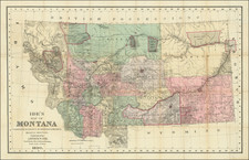
Fascinating Miner's Birdseye view style map of the mining regions in the Tobacco Root Mountains, south of Mammoth, Montana, possibly associated with the operations of the Sultana Mining Company at the end of the 19th Century.
Viewed from the north (with South at the top), the map shows a section of the Tobacco Root Mountains, centered on the South Boulder River and the Wagon Road from Mammoth. The map illustrates several cabins, mining claims, creeks and topographical features, including the locations of Gold Mines (Curley Bill Gold, Mt. Cliff Gold and Ring), as well as Copper mining areas.
The location of the Sultana Mining Company Mill is also shown. This likely relates to mining activity which began south of Mammoth, Montana in the late 1890s.
Gold was first discovered in the Tobacco Root Mountains near Virginia City in 1863. Mining gold continued into the 1930s.
Place names of note on the map include:
- Mammoth, Montana
- Pony, Montana
- Fork City
- Curley Creek and Curley Creek Falls
- Wisconsin Creek
- Mt. Cliff
- Copper Mountain
![[Montana, Wyoming, Dakota, Upper Missouri River] Amer. Sep. No. 40. Partie des Etats Unis](https://storage.googleapis.com/raremaps/img/small/93546.jpg)
![Map of Oregon, Washington and Part of Idaho [First Appearance Of Idaho Territory, including western Montana and Western Wyoming]](https://storage.googleapis.com/raremaps/img/small/94211.jpg)